
Basin And Range Trail Thru Hike Guide
Basin and Range Trail Introduction

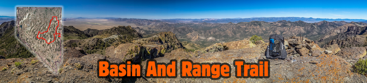
Map of the Basin and Range Trail
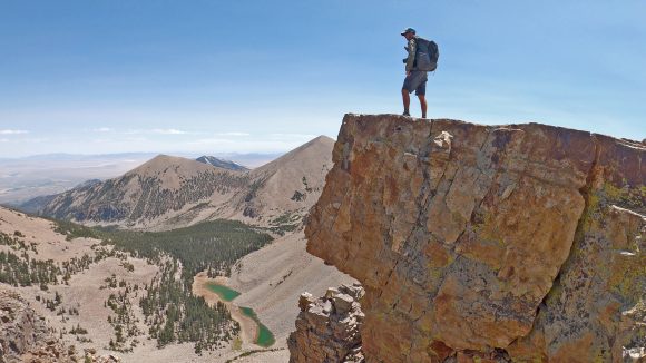
The Basin and Range Trail (BRT) is a 1,090-mile hiking route through Nevada’s Basin and Range country, more commonly referred to simply as the Great Basin. Nevada is home to more than 310 mountain ranges, second only to Alaska. Most of these mountain ranges are tall, narrow and run parallel to each other in a north-south configuration. In between these mountain ranges lies vast arid valleys, or basins. The Basin and Range Trail was created to explore this unsung landscape, a region with few established hiking trails and very little information on what is even out there. In short, the allure of the unknown inspired this route.
The BRT offers a different kind of thru hiking adventure, more raw and rugged than those within the National Scenic Trail system. The BRT is not a blazed trail, a beaten path or even a 100% fully ground-truthed route. Routes of this nature are constantly evolving, seeking the best scenery and most interesting hiking, the optimal route. As more hikers take on the Basin and Range Trail, various alternate routes are explored and feedback is gathered, the future will see many updates to the current route. Thru-hiking the Basin and Range Trail means off-trail hiking and bushwhacking, and hikers setting foot here should understand that this is part of the adventure.
The Basin and Range Trail is split up into 10 sections, and could end up being anywhere from 900-1100+ miles, depending on the route you take. There are many options for alternates and cutoffs. It begins in Ely and forms a large “loop” through the state, nearly ending in Ely but actually ending in Baker. The BRT is best suited for a clockwise hike. Late spring/early summer is the optimal window. Expect 45-55 days of hiking. There is a lot of rugged cross-country terrain with a lot of bushwhacking, so the pace is slower than a normal thru hike.
Read the Las Vegas Review Journals’ story on the Basin and Range Trail
BRT 1.0 vs BRT 2.0
The version of the Basin and Range Trail I hiked could be considered 1.0. Since my first attempt of this route, it has undergone major revisions to take advantage of the first-hand knowledge I gained by getting my feet on the ground and actually hiking the route. Large portions of my original route have become the standard route, some portions of the original route are now alternate routes, and some portions of the original route have been scrapped and re-routed all together. Keep in mind that the Basin and Range Trail experience presented in my journal only partially represents the standard Basin and Range Trail route presented in the Official Guidebook and Map Set, which could be referred to as BRT 2.0.
Basin and Range Trail Thru Hike Journal And Photos

Goshute Range Traverse
1 – Ely to Preston: 94 Miles (87 Miles)
2 – Preston to Tonopah: 120 Miles (110 Miles)
3 – Tonopah to Carvers: 116 Miles (124 Miles)
4 – Carvers to Austin: 95 Miles (94 Miles)
5 – Austin to Eureka: 106 Miles (59 Miles)
6 – Eureka to Lamoille: 131 Miles (123 Miles)
7 – Lamoille to Wells: 80 Miles (70 Miles)
8 – Wells to Wendover: 113 Miles (83 Miles)
9 – Wendover to Ely: 125 Miles (105 Miles)
10 – Ely to Baker: 111 Miles (96 Miles)
BRT 2.0 Total: 1091 miles My Total: 951 Miles
*Note: I want to present both my actual mileage hiked, but also, the mileage of the standard route for future BRT thru hikers. Read the above mileages as follows: “1 – Ely to Preston: 94 Miles (87 miles)”… the 94 miles represents standard BRT route presented in the guidebook (BRT 2.0), while the 87 miles represents the actual miles I hiked on my version of this section (BRT 1.0). Basically, this is a quick way of understanding how many miles I hiked that section, compared to what the total is for that section moving forward in BRT 2.0.
Basin and Range Trail Thru Hike Videos
I filmed carried 6lbs of electronics and camera gear to film my Basin and Range Trail thru hike. After the hike, I then spent well over 1,000 hours editing and producing a 10 part series documenting my Great Basin thru hike experience, as well as a feature film that condenses the Basin and Range Trail thru hike adventure down to 60 minutes. Watching these videos is the best way to get a feel for a Great Basin thru hike, to see the beauty of Nevada but also the difficulty of the route.
10 Part Basin and Range Trail Thru Hike Vlog Series
Basin and Range Trail Thru Hike Documentary Film
Basin and Range Trail Thru Hike Documentary Film on Streaming Services
You can watch the 60 minute Basin and Range Trail Documentary Film for free on youtube, but if you’d prefer, you can also watch it on the following streaming services:
- Amazon Prime
- Xumo
- Tubi
- Filmocracy
- Telus
- Overdrive
Basin and Range Trail Guide
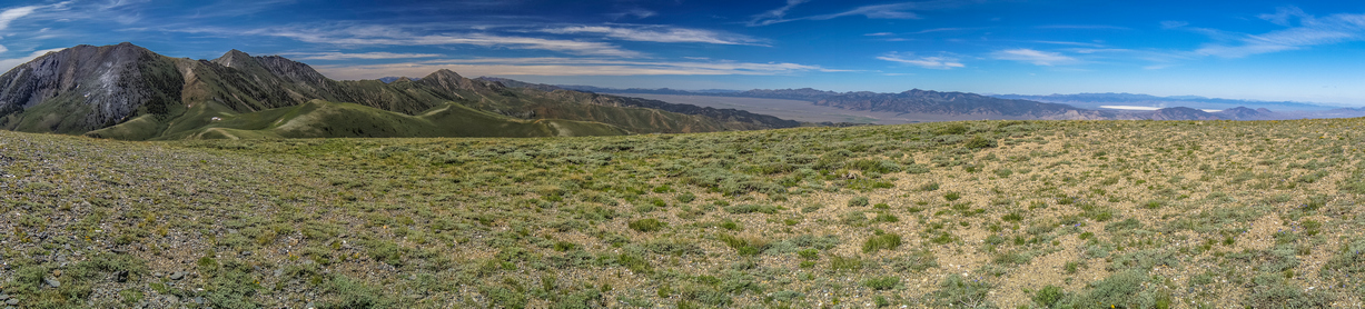
Toiyabe Range, Reese River Valley and the Shoshone Range viewed from the Toiyabe Crest Trail
Now that you’ve read the BRT Journals and watched the Basin and Range Trail movie/vlog series, you may be interested in the more technical aspects of the hike. Perhaps to plan a thru hike, or section hike, of the Basin and Range trail yourself. The information below is meant to be a condensed guide to give the potential BRT hiker a quick look at the basic logistical aspects of planning your own hike.
The Official Guidebook and Map Set is the most complete, detailed Basin and Range Trail planning resource available for those who are serious about thru hiking their own version of the Basin and Range Trail. The route is well documented in the available 120 page guidebook, GPX file of the route, PDF map sets, water chart and more. The Basin and Range Trail planning resources are detailed and thorough, everything you need to hit the ground. The complete BRT planning guide and GPX kit is available for free to those who join the Basin and Range Trail Facebook group , which is the best way to get in touch with other past, present and future BRT thru hikers, trail angels etc.
Start and End Points
The Basin and Range Trail starts in Ely and ends in Baker. The route nearly forms a loop, but doesn’t actually end in Ely, although a hiker could if he/she so chooses. Getting to and from the start and end points of the BRT is a challenge. Ely doesn’t offer the hiker much in terms of transportation options. There are no airports, trains, bus routes, uber, taxi services or shuttles that operate out of Ely (population 4,000). Therefore, ending the hike in Baker (population 58) puts the hiker in a roughly similar situation, the need to find a ride to a larger town for transportation back home. If you don’t have a friend willing to drive you to and from the terminus points, your best bet is rideshare listings on facebook or craigslist. And of course, thumbing it as a last resort. Remember, the trial provides. If you can get to it.
Direction of Travel
The route is best hiked in a clockwise direction. The route ends at Wheeler Peak (13,065′) in Great Basin National Park, so you aren’t going to want t be at that elevation too early in the season. The Snake Range, encompassing Mt Moriah and Great Basin National Park, is best hiked last along the BRT. In general, the southern leg of the BRT is lower in elevation, as well as latitude, and so it can be hiked earlier in the season. For these reasons, it’s best to hike clockwise. A counter-clockwise hike of the BRT would likely require different start and end points.
Seasonality
The BRT could be hiked in the spring, summer and fall. However, most hikers will prefer this hike in May to July timeframe. The southern portion of the route is the warmest/lowest elevation, and that is why it is hiked first. In many years (snow has been low in recent years) the Toiyabes hold significant snow into June. The Rubies, Schell Creek Range and the Snake Range can all hold snow into July. In the southern portion, the Egans and Grant ranges both spend time over 10k feet, and reach 11k feet, so these can hold snow later into the season as well. Those who don’t mind the snow, or don’t mind bailing and walking around if high snow is encountered, can start earlier in the season, say, April. Those looking for a snow-free hike should wait until around 1st or second week of May at least, potentially later depending on the year. Start too late and the heat is an issue from mid July on, and water sources start to dry up. The ideal start date is based off the snowpack for the current year. Your goal is to have snow melt to draw water from while hiking the crest of the Toiyabes and Diamonds, in sections 4 and 6.
Time on Trail
The miles here are MUCH slower than a typical thru hike, because of the frequent bushwhacking and cross-country hiking across rough terrain. The hike will take much longer if you stick with the bushwhacking, not bailing out and taking alternates. The route variables could mean a total mileage of 900-1100+, which also has a big effect on your time to complete the route. Not counting zero days, figure 45-55 days for a “typical” thru hike of about 1000 miles.
Type of Hiking
Approximate breakdown of surface types along the Basin and Range Trail and their estimated percentages:
Single Track Trail – 10%
Cross-Country Hiking – 35%
4×4 Roads – 35%
Dirt Roads – 15%
Paved Roads – 5%
The majority of the hiking along the Basin and Range Trail is either cross-country or on a 4×4 road, many of
which are very old and faded. There are practically no hiking trails along the route, except in the Toiyabes,
Rubies, Mt. Moriah and Great Basin National Park. If you see a hiking trail marked anywhere else on the map,
chances are, it doesn’t actually exist on the ground. Sometimes, the same is true for 4×4 roads. If you do
encounter a trail, it likely needs some maintenance as most are overgrown. Many of the trails encountered are actually horse trails,
which quickly fade in and out.
Maps
Download the Basin and Range Trail GPX file & PDF Map Set. The GPX file and PDF maps are FREE for those who join the Basin and Range Trail facebook group, or available for purchase using the first link. You can can use the GPX file with the mapping platform of your choice (I recommend caltopo). The GPX file includes all of the water sources as waypoints as well.
Water
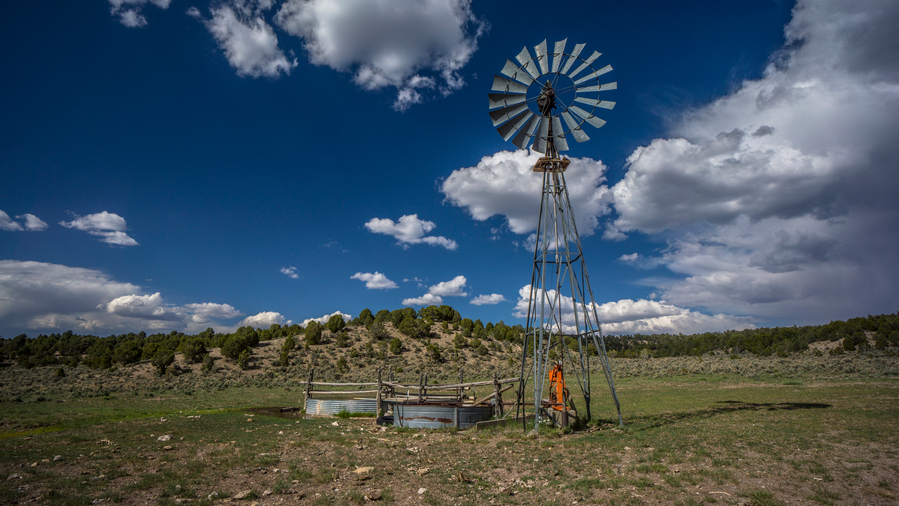
Windmill with good water in the Egan Range/Cave Valley
Water is perhaps the biggest concern a potential Basin and Range Trail thru hiker has when considering this trail. To those unfamiliar with Nevada, the prospect of finding reliable water in Nevada sounds daunting, and downright dangerous. However, this is not the case. Nevada is the driest state in the country, and even during an exceptional drought, in the middle of summer in 2020, I generally had no problem finding water.
The water availability along the BRT could be considered comparable to that of New Mexico on the Continental Divide Trail. There are plenty of days where you will have multiple water sources, and there are many days where you will only have one. It’s a dry and arid climate, but there is almost always water, when you know where to find it. They key is pre-hike planning.
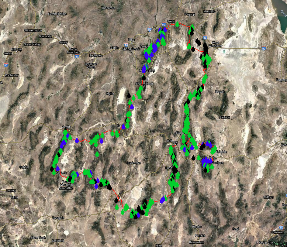
Water sources plotted along the route, color coded for ease of visibility and understanding: Blue = Reliable, Green = Probably/Maybe, Black = Dry
The longest distance in between water sources for me was roughly 25 miles. The standard BRT route as presented in this guidebook has a water carry of up to 38 miles, but potentially as low as 25 depending on the route taken. In total, the BRT has 4 water carries over 20 miles. In general, water is pretty easy to come by, for such an arid climate. In short, water is not as big of a deal as you might think in Nevada.
Most of Nevada’s precipitation falls in the form of snow, and after snowmelt is when water is most abundant. Snow remains longer into the spring and summer season in some ranges than others. The taller the mountains, generally, the wetter they are. In most ranges, the large canyons have water. Many of these water sources in the mountains are flowing creeks.
Water Chart
Besides the GPX file of the route, here’s perhaps the single most important piece of planning info available for a thru hike of the Basin and Range Trail: the Water Chart. All of these water sources are plotted along the GPX file as well, so you can view these water sources along an interactive map.
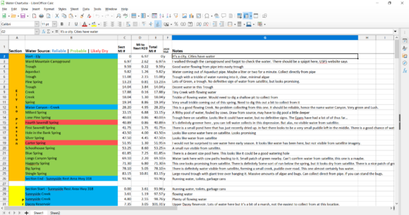
*This chart is set to View Only, so if you have any updates to this chart, contact me directly and I will add your notes/updates here to the Basin and Range Trail Master Water Chart.
Bushwhacking
To be blunt, there is a shitload of bushwhacking along the Basin and Range Trail. This route was never meant to be conservative, ensuring easy passage or safety. It was meant to be the next-level adventure I was looking for after completing the CDT. For me personally, that meant mapping my own route, going off-trail, and dealing with whatever it was I got myself into. I knew I would be bushwhacking, and I accepted this going into it. I wanted to reach places that looked intriguing to me via satellite, or perhaps, simply connect segments of the route that would not otherwise be possible if one were not willing to put forth the extra effort in bushwhacking. If you don’t want to do any bushwhacking, I don’t blame you. But unless you are willing to do what others won’t, your adventures will be confined to the path more frequently traveled.
The worst bushwhacking along the BRT was in the East Humboldt Range, and the Goshute Range. The East Humboldt Range is notorious for being overgrown, and as wet as it is, can be thicker than anything else you’ve encountered along the BRT. The supple new growth aspens bend easily, but grow so thick that you’ll feel like you’re swimming in them above the ground. The Goshute Range, on the other hand, is much drier. Here, Mahogany Trees are the main obstacle. They grow thick too, but are stiff and brittle. In other words, it hurts more.
One option to consider is having a pair of gloves to protect your hands. They will become torn up without them as you constantly grab and snap branches on some of these bushwhacks. I didn’t have them at the time, but I am now wearing these Fish Monkey Fingerless Gloves. The inside of the palm is a soft flexible leather, and the outside is like a thin neoprene material. The gloves feel light and flexible, yet provide good protection for the hands while bushwhacking.
Weather & Climate
Those unfamiliar with Nevada often think of the state as a giant extension of Las Vegas, one big hot desert. Many are surprised to realize that the rest of the state varies as much as it does. Las Vegas sits in a valley at around 1800’ elevation, while the lowest point along the BRT is 4800’. Only once does it dip below 5000’. Most basins are around 5500’, with some as high as 6500’. Those are the LOW points along the route. Sure, it can be hot on the BRT, but nowhere near as hot as Las Vegas, due to higher elevations. Central and northern Nevada is a different environment. The rest of the state does not see the 115 degree temps that Las Vegas does.
See the Koppen climate classification map of Nevada below, with the BRT route overlaid:

You can see in southern Nevada, the red, which indicates “hot desert”. This is the desert most people think of when they think of deserts. In the southern portion of the route, along sections 2 and 3, you will encounter “cold desert” environments, but the rest of the low valleys along the route are mostly “cold semi-arid”. The mountain ranges are mostly “warm-summer Mediterranean continental” and to a lesser extent, “warm-summer Mediterranean”.
Expect bluebird skies nearly every day in June with mild temps. The low valleys aren’t too hot this time of year, and can actually be quite cold still on occasion throughout June. There is still the possibility of snow storms in June, expect a dusting or two at high elevations. The temps heat up around the beginning or July, and getting uncomfortable by mid July. Afternoon thunderstorms were sparse during my 2020 thru hike, only occurring within a one week window in late July. July and August will routinely see temps of the 90s and during a heat wave, the low 100s in the valleys along the BRT. It’s almost always windy in Nevada, and the winds are often high. The good news is that the winds generally die down at night. There are very few overcast days, so be prepared to be exposed to direct sunlight for the majority of your hike.
Mountain Ranges of the Basin and Range Trail
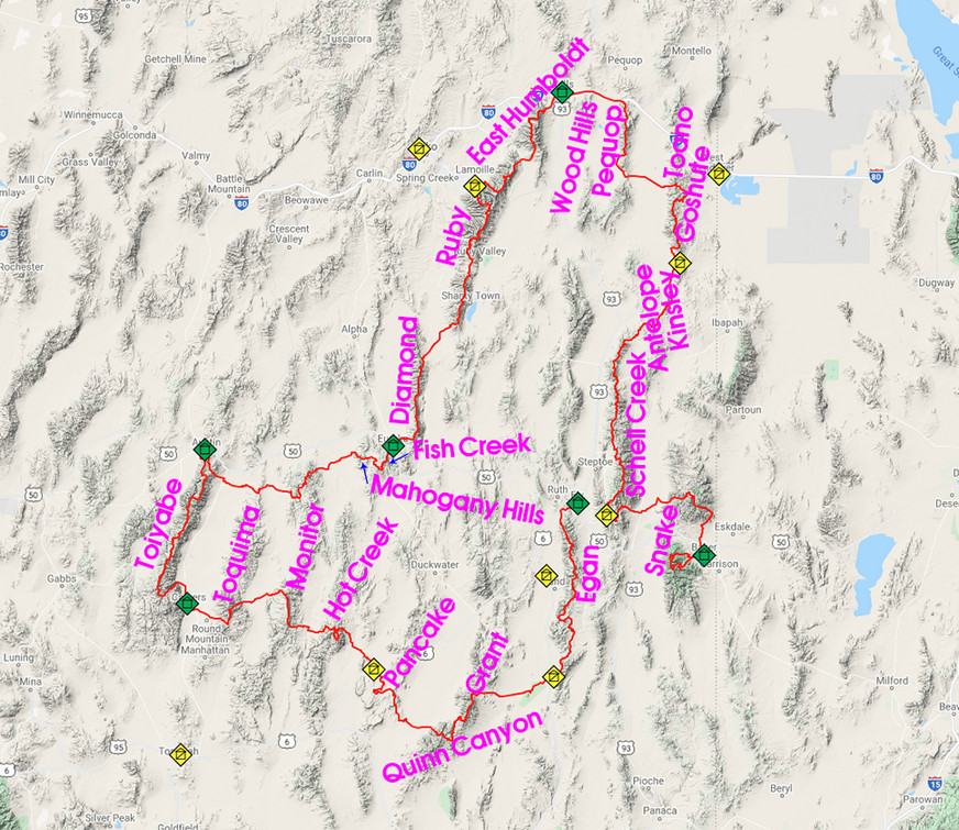
Mountain Ranges of the Basin and Range Trail
Valleys (Basins) of the Basin and Range Trail
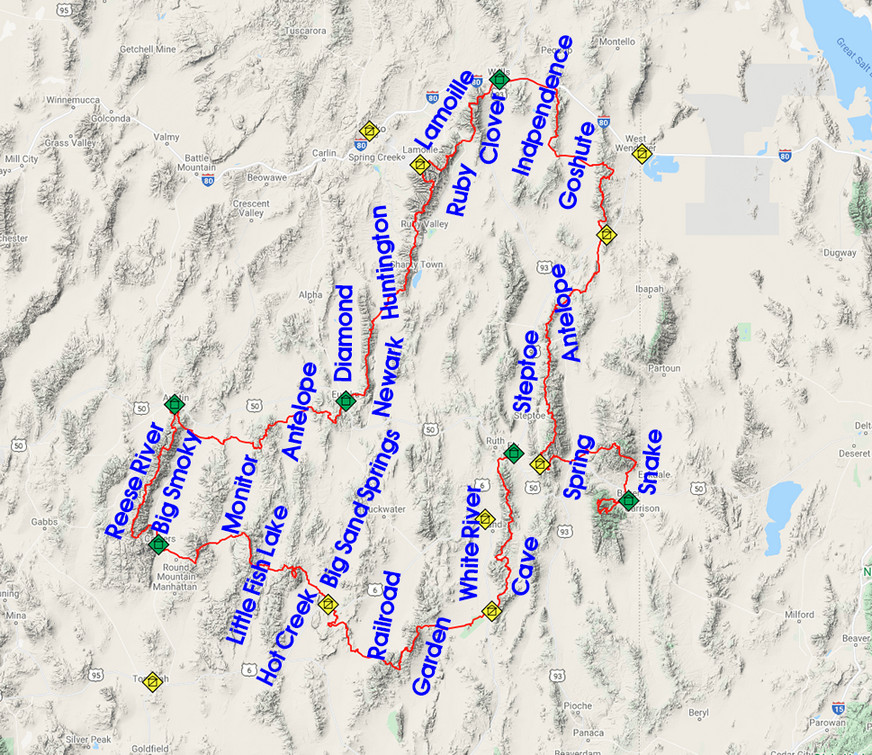
Valleys/Basins of the Basin and Range Trail
Town Stops & Resupply

The Basin and Range Trail was created with as many walk-in town stops for resupply as possible, as opposed to hitching. Even so, half of the town stops require hitching. The towns are small and extremely isolated along most of the route. Besides the I-80 corridor along the northern end of the route, the biggest towns are Ely with 4,000 and Tonopah with 2,000. The other towns have little to offer. Preston, Carvers and Austin do not have grocery stores, so you’ll need to send a food box to these towns.
With the need to charge electronics and dump media from my cameras, I generally stay in a hotel in town. If I am sending myself a package, I’ll send it to the motel I plan on staying at. This is preferred over sending to a post office, because then you are not tied to their hours when you get into town. For example, get into town Saturday afternoon, and you’ll need to wait until Monday to get your box from the post office. Mailing to a motel eliminates that problem.
For a detailed Town Guide, check out the Basin and Range Trail Guidebook
Caching
It is not necessary to cache food or water anywhere along the Basin and Range Trail, unless you wish to do so. I did not employ this strategy as I rely on towns to recharge my electronics, dump media from my cameras and backup data.
If I were to cache, I would do so in place of the towns that require a hitch. So, I would cache at the end of section 1 (Sunnyside), section 2 (Lunar Crater), section 6 (Lamoille Canyon), section 8 (US 93 Alt) and section 9 (Cave Lake State Park). Of course, anywhere your route crosses a road will work, and selecting exact cache locations is up to you.
Related Images:
Basin and Range Trail Thru Hike Complete!
Woohoo!! 1000+ mile Basin and Range Trail thru-hike complete!
The BRT is a brand new long distance thru hike route that I created and hiked over 67 days through Nevada this summer. Nevada is the most mountainous state in the country, outside of Alaska, with over 310 separate mountain ranges. The BRT aims to combine as many of the best mountain ranges in the state as possible in one long loop-style thru hike route. In much of the Great Basin, specifically central Nevada, the term “Basin and Range” is used to describe the topography… an alternating landscape of parallel mountain ranges and valleys. Hence, the name Basin and Range Trail.

I created the Basin and Range Trail to satisfy my curiosities about Nevada. For a chance to explore a mysterious region almost entirely untouched by the backpacking community. I never knew what to expect, whether or not the route down this mountain or canyon would pan out. Whether or not I would find water. With so little available information about the area, water sources etc, every single day was a real adventure. Every single day, I felt like I was walking into the unknown.
-

Hot Spring along the BRT -

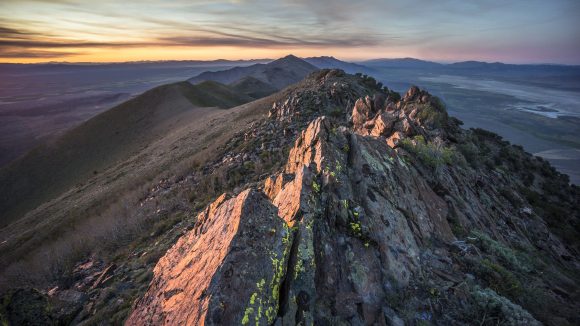
Sunset in the Toiyabe Range -

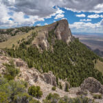
Crest of the Goshute Range -

Waterfall in the Ruby Mountains -

Exploring a forgotten gold mine -

Conquering the canyon -

Lunar Crater -

Railroad Valley -
Diamond Mountains

Nevada is crazy wild. The majority of the state sees extremely little human use. Mostly hunters and ATV riders, and exponentially less use by hikers. You will seldom be the “first person to walk here”, but you will often feel like it. There aren’t many places left like that. The towns are small and isolated, often around 100 miles from the nearest/next anything. Many towns don’t even have a grocery store, and rural Nevadans routinely drive 200 miles for food. Things are spread out here on a scale that you must see to comprehend. That is one of the things that brought my attention to Nevada, and a big part of the draw to hiking here.
Along my 1000+ mile walk on the BRT, I encountered hundreds of wild horses, many elk, deer, big horn sheep, badgers, and only two rattlesnakes. I discovered numerous caves, countless creeks, waterfalls, and summitted the high points of several mountain ranges. I dodged lightning strikes, saw the oldest living things on earth (Bristlecone Pine trees), swam in hot springs, walked the pony express trail, cowboy camped under the starriest night skies imaginable, visited a nuclear test site, found arrowheads and Indian artifacts, had 6am wake up calls from the sonic boom of military aircraft, explored forgotten mine shafts, battled 102 degree temperatures and crossed dried lake beds, bushwhacked my way to hell and back, collected rocks along the way including many garnets, cowboy camped in a cave, and nearly got swept off a cliff by a dislodged boulder. I feel incredibly lucky to have seen and experienced what I have, and to have returned relatively unscathed.
I ended my 67 day BRT journey in the town of Baker, NV which has a population of 68. Ending alone, in a small town like this, is rather anti-climatic. It’s a quasi-loop route, with no definitive start/end points like the CDT, PCT, AT etc. No monument to celebrate at. I stretched out the miles on my final day walking into town, giving myself a little time to process the completion of my most ambitious adventure yet. The array of emotions one feels at the end of such a journey are varied and quite intense. All the trials and triumphs of a months-long expedition have passed, and suddenly, your goal is complete. It’s a great feeling, a relieving feeling, to be done and to be able to relax. On the other hand, it’s difficult to comes to terms with… is it possible this may have been my greatest adventure, never again to be topped? What does the future hold? Indeed, much to ponder, an entirely different topic on it’s own. It’s been a real privilege to spend a summer roaming here.
**I’ve filmed the entire hike (carried 6lbs of camera gear, roughly 1/3 my baseweight) with the intent of producing a movie, as well as a vlog-style video series for YouTube. 𝐒𝐮𝐛𝐬𝐜𝐫𝐢𝐛𝐞 𝐡𝐞𝐫𝐞 𝐭𝐨 𝐬𝐭𝐚𝐲 𝐢𝐧 𝐭𝐨𝐮𝐜𝐡:
👉 https://www.youtube.com/c/SeekingLost
I also plan to release detailed info on the route (website/guidebook) for anyone who would like to take on the Basin and Range Trail themselves. And finally, I plan to write a book about my journey, as it has been just too powerful of an experience not to share in greater detail!
Stay tuned for more updates throughout the fall. Happy trails!


