
Basin and Range Trail Thru Hike Complete!
Woohoo!! 1000+ mile Basin and Range Trail thru-hike complete!
The BRT is a brand new long distance thru hike route that I created and hiked over 67 days through Nevada this summer. Nevada is the most mountainous state in the country, outside of Alaska, with over 310 separate mountain ranges. The BRT aims to combine as many of the best mountain ranges in the state as possible in one long loop-style thru hike route. In much of the Great Basin, specifically central Nevada, the term “Basin and Range” is used to describe the topography… an alternating landscape of parallel mountain ranges and valleys. Hence, the name Basin and Range Trail.

I created the Basin and Range Trail to satisfy my curiosities about Nevada. For a chance to explore a mysterious region almost entirely untouched by the backpacking community. I never knew what to expect, whether or not the route down this mountain or canyon would pan out. Whether or not I would find water. With so little available information about the area, water sources etc, every single day was a real adventure. Every single day, I felt like I was walking into the unknown.
-

Hot Spring along the BRT -

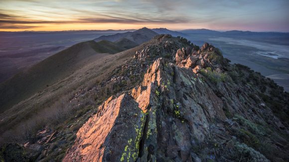
Sunset in the Toiyabe Range -

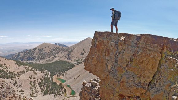
Crest of the Goshute Range -

Waterfall in the Ruby Mountains -

Exploring a forgotten gold mine -

Conquering the canyon -

Lunar Crater -

Railroad Valley -
Diamond Mountains

Nevada is crazy wild. The majority of the state sees extremely little human use. Mostly hunters and ATV riders, and exponentially less use by hikers. You will seldom be the “first person to walk here”, but you will often feel like it. There aren’t many places left like that. The towns are small and isolated, often around 100 miles from the nearest/next anything. Many towns don’t even have a grocery store, and rural Nevadans routinely drive 200 miles for food. Things are spread out here on a scale that you must see to comprehend. That is one of the things that brought my attention to Nevada, and a big part of the draw to hiking here.
Along my 1000+ mile walk on the BRT, I encountered hundreds of wild horses, many elk, deer, big horn sheep, badgers, and only two rattlesnakes. I discovered numerous caves, countless creeks, waterfalls, and summitted the high points of several mountain ranges. I dodged lightning strikes, saw the oldest living things on earth (Bristlecone Pine trees), swam in hot springs, walked the pony express trail, cowboy camped under the starriest night skies imaginable, visited a nuclear test site, found arrowheads and Indian artifacts, had 6am wake up calls from the sonic boom of military aircraft, explored forgotten mine shafts, battled 102 degree temperatures and crossed dried lake beds, bushwhacked my way to hell and back, collected rocks along the way including many garnets, cowboy camped in a cave, and nearly got swept off a cliff by a dislodged boulder. I feel incredibly lucky to have seen and experienced what I have, and to have returned relatively unscathed.
I ended my 67 day BRT journey in the town of Baker, NV which has a population of 68. Ending alone, in a small town like this, is rather anti-climatic. It’s a quasi-loop route, with no definitive start/end points like the CDT, PCT, AT etc. No monument to celebrate at. I stretched out the miles on my final day walking into town, giving myself a little time to process the completion of my most ambitious adventure yet. The array of emotions one feels at the end of such a journey are varied and quite intense. All the trials and triumphs of a months-long expedition have passed, and suddenly, your goal is complete. It’s a great feeling, a relieving feeling, to be done and to be able to relax. On the other hand, it’s difficult to comes to terms with… is it possible this may have been my greatest adventure, never again to be topped? What does the future hold? Indeed, much to ponder, an entirely different topic on it’s own. It’s been a real privilege to spend a summer roaming here.
**I’ve filmed the entire hike (carried 6lbs of camera gear, roughly 1/3 my baseweight) with the intent of producing a movie, as well as a vlog-style video series for YouTube. 𝐒𝐮𝐛𝐬𝐜𝐫𝐢𝐛𝐞 𝐡𝐞𝐫𝐞 𝐭𝐨 𝐬𝐭𝐚𝐲 𝐢𝐧 𝐭𝐨𝐮𝐜𝐡:
👉 https://www.youtube.com/c/SeekingLost
I also plan to release detailed info on the route (website/guidebook) for anyone who would like to take on the Basin and Range Trail themselves. And finally, I plan to write a book about my journey, as it has been just too powerful of an experience not to share in greater detail!
Stay tuned for more updates throughout the fall. Happy trails!
Related Images:
CDT Blog Posts Postponed Until Hike Completion
I have decided to hold off on posting CDT hike updates while on trail for the sake of time. It takes the better part of a whole day to update the blog with 2-3 posts, and I am spending more time than I should on a computer in town. I need this time to do chores (laundry, groceries, gear repair, etc), and have been taking extra days off in town just to complete my blog updates. Extra days in town means more money spent, and lessens my chances of making it to Canada in time before the weather turns.
I will still be keeping a detailed journal throughout the rest of the hike. When I return home in the fall, I’ll complete my blog updates for the remainder of the CDT. Thank you all for your support and understanding.
Related Images:
3-12-14 Update – Server Problems, Missing Content
I had some issues with my server recently and all of my files were deleted. The only backup I had for this site was old, and didn’t include most of my photos, so it’s going to be a long time before I have everything back to normal. Just wanted to let everyone know what’s going on and explain why the site is so bare right now. Lesson learned, always keep good backups.
Related Images:
Planned Hike – High Country Pathway (HCP) in Michigan
As much as I’d like to get away from Michigan for a real hike, it’s not in the cards right now. However, I will have a week off and plan on hiking somewhere semi local. There is an 80 mile loop in the Pigeon River Country State Forest that is supposed to be the closest thing to wilderness in Michigan’s Lower Peninsula. It’s called the High Country Pathway. I’ve hiked a 5-6 mile section here before, but it ended up being more of a fishing trip after we found a nice spot along the Pigeon River where we pulled out several Rainbow and Brook Trout. The trail is not spectacular by any means, but it’s really close to home at only 3.5 hours. The Pigeon River Country State Forest may be best known for being home to the largest herd of free-roaming elk east of the Mississippi River. Hopefully I’m lucky enough to spot one myself.
It took a long time to find a gpx file online of the HCP. After loading the GPX into Basecamp, I saw that the total elevation gain was only 6200ft for the entire trail. Honestly, I thought it would be less. Still, that’s nothing. I’m going to try and do this 80 mile loop in 4 days. I normally take a ton of pictures on my hikes, but that’s when there is beautiful scenery everywhere. I don’t think I will have much to photograph on this trip, so it will be interesting to see how many miles I can cover in a day.
I could only find about 3 trip reports from those who have hiked the entire HCP. Not many people hike it. I hear it’s supposed to be pretty wild, for the Lower Peninsula anyways. So, I’m gonna check it out, and I’ll get a trip report up soon enough.
Related Images:
Planned Hike – Superstition Wilderness, AZ

Well, I am going on another backpacking trip in a few days. The weather sucks here in Michigan right now so my timing couldn’t be better. I guess you can’t skip winter every year. Anyways, my escape is the Superstition Wilderness of Arizona, a 160,000 acre tract of land within the 3 million acre Tonto National Forest. I’ll be hiking 6 days and have a 88 mile route planned. I will also be going solo for this trip, which I haven’t done since the Porcupine Mountains.
After experiencing some pretty painful knee pain during my last hike in Linville Gorge, NC, I started looking into reducing my pack weight. I’m going to go into more details on this in another post, but so far I’ve shaved off around 8lbs! The biggest weight savings came from a new backpack and making a lightweight tripod to replace my bulky 2lb’er.
Along with reducing my pack weight, I modified my exercise routine. I did some research on knee pain related to backpacking, and realized that I may not be working out my hamstrings enough. I do squats for my quads regularly, but seldom do deadlifts. This may cause a muscular imbalance leaving the hamstring weaker than the quads, causing knee pain going downhill. I don’t really like doing deadlifts though, especially before a backpacking trip because I can’t run for several days afterwards. My lower back is just too sore. But then I read about SLDLs (stiff leg deadlifts) and realized that these target the hamstrings much more aggressively than regular deadlifts. I’m doing much less weight but my hamstrings are still pretty sore the next day, and my lower back doesn’t hurt as much. Probably due to lifting much less weight. The consistently foul weather has prevented me from running as much as I usually do, so I’ve been doing more stair climbs instead. I loaded up my backpack with 50 pounds and do around 30 minutes up and down my basement stairs. Trust me, it’s a great workout!
I also added a joint supplement to my diet. I have been taking Osteo Bi-Flex twice a day for the last month, and will be bringing it on my trip as well. It’s 2 main ingredients, glucosamine and chondroitin, are supposed to help build and lubricate cartilage. I can’t say whether or not they work just yet. All I know is, I never though I’d be taking a pill with a name like Osteo Bi-Flex until I got my AARP card. Sure does make you feel old.
This hike is going to be about twice the length of anything I’ve done so far, but I’m excited as hell. With a lighter pack, lighter footwear (wearing my Merril Moab Ventillators instead of my Zamberlain Vioz GT boots), and an improved exercise regiment, I’m hoping to cover more ground and with less effort. Either way, it’s sure to be an adventure. I’ll get a trip report up as soon as I can!
Related Images:
20 Best Backpacking Photos For 2012
I thought it would be cool to compile a list of the best pictures from all of my backpacking trips this year. It was hard to narrow it down to 20, so many good ones! From the summit of Snowmass Mountain to the Chihuahuan Desert, 2012 was one hell of a year. Many of my favorite backpacking moments are depicted in these pictures, such as overlooking the Whitewater-Baldy Fire in the Gila Wilderness (picture 4). This fire would later grow to be the largest in New Mexico’s history at over 270,000 acres.
Enjoy the pictures, and don’t be afraid to leave comments!
1.

Snowmass Mountain viewed from Snowmass Lake
2.

Fog fills the valleys of the Dolly Sods Wilderness, WV
3.

View from Trail Rider Pass in the Maroon Bells Wilderness, CO.
4.

Me overlooking the Whitewater-Baldy Wildfire in the Gila Wilderness, NM. This would later grow to become the largest wildfire in New Mexico history!!
5.

Lead King Basin in the Maroon Bells Wilderness, CO.
6.

Chihuahuan Desert viewed from the South Rim in the Chisos Mountains of Big Bend National Park, TX
7.

Linville Gorge, NC
8.

The Chimneys, Linville Gorge, NC
9.

Exploring a cave along Blue Creek in Big Bend National Park, TX. This picture made it into the Big Bend National Park 2013 calendar!
10.

Frigid Air Pass behind me in the Maroon Bells Wilderness, CO
11.

Sunrise over the Chihuahuan Desert, Big Bend National Park, TX
12.

Panoramic view from the top of Snowmass Mountain, 14,098ft
13.

Early morning in the Linville Gorge Wilderness, NC
14.

Sunrise in the Dolly Sods Wilderness, WV
15.

Linville Gorge Wilderness, NC
16.

Big Bend National Park, TX
17.

The Chisos Mountains of Big Bend National Park, TX
18.

A very lonely stretch of road in Big Bend National Park, TX
19.

Table Rock in the distance. Linville Gorge Wilderness, NC
20.

Helicopter flying through the smoke of the Whitewater-Baldy wildfire in the Gila Wilderness of New Mexico
Related Images:
2012 Year’s End Review

At the top of Frigid Air Pass in the Maroon Bells Wilderness, CO
Wow, 2012 was a great year! I’ve never done so much traveling in my life, and I’m not complaining. Backpacking has given me the opportunity to see some pretty amazing things across the country, and what has started as a hobby is quickly becoming an addiction!
Below is a quick rundown on some of the note worthy “stats” for my 2012 year:
I drove 30,000 miles
Visited 20 states
Hiked approx. 190 miles
Climbed my first 14er, solo
Witnessed the largest forest fire in New Mexico history while hiking in the Gila Wilderness
Went sky diving for the 3rd time in 3 different states
Went to Florida and visited 3 new springs: Troy Spring, Devil’s Den and Little River Spring
Had one of my photos make it into the Big Bend National Park 2013 Calendar (Mine is February)
You might also be interested in my 20 Best Backpacking Photos Of 2012.
Woohoo, bragging rights! Seriously though, I learned a lot this year and feel like I stepped up my hikes quite a bit. All of my backpacking trips went fairly well with only minor hiccups along the way. Most of my gear has remained the same, but I am slowly discarding things to lighten my pack. It’s just so hard to make sacrifices!
My exercise regiment may not have been as intense as it was in 2011. Last year, I had a roommate who was a very good workout partner, and we hit the weights 4 days a week for 6 months straight. I also managed to fit in 1-2 days of running per week. This year, I have had no workout partner which really sucks. No spot for the bench press and other exercises, and nobody to motivate you. I would say I averaged 2 days of weights and 1 day of running per week throughout the year. My diet has remained spot on though and I still look and feel just as good as I did last year, so no complaints!
Well, I hate to say it, but goodbye 21012… bring on the new year!! Where will I hike next? Find out in my next post: My Goals And Planned Hikes For 2012
Related Images:
My Goals And Planned Hikes For 2013
After an amazing year of backpacking in 2012, I’m eager to keep the ball rolling in 2013. Living in Michigan makes it pretty hard to hike a lot though, and especially if I want to hike anywhere remotely worthwhile. I’ve realized that where I want to be ultimately is out West somewhere, and I’m in the process of formulating a 2-3 year plan to get the hell out of here. Right now, Denver is looking like my best option, but it’s still way too early and I have a lot to ponder. I just know that I don’t want to live here, and I do want to live closer to the things I enjoy.
As far as planned hikes go for 2013, I don’t have any set in stone yet. Of course, there’s about a million that I want to do! The reality of this year is that I probably won’t have the time to go on long trips like I did in 2012. I really hope this is not the case, but it’s looking that way. However, if I can get the time, one trail that I would really like to hike in 2013 is the John Muir Trail. Located in California, this 210 mile trail runs from Yosemite to Mt Whitney through beautiful High Sierra country. It passes through 3 National Parks: Yosemite, Kings Canyon and Sequoia. About 160 miles of this trail is also part of the Pacific Crest Trail (PCT). The John Muir Trail is more than 4 times longer than anything I’ve hiked so far, but that’s why I want to do it.

Yosemite National Park, northern terminus of the John Muir Trail
My hikes in 2012 were a big step up from what they were in 2011. I hope to continue to push myself in the coming year by hiking longer trails and increasing my mileage per day. In 2012, I wasn’t concerned with covering a ton of miles each day, but rather to have time to explore the little things along the way. I love that stuff… the little unexpected discoveries that are everywhere just off the trail. But, I feel it’s time to push myself harder and I’d like to be able to cover around 20 miles per day. The most miles I’ve covered in one day so far is 13.8 I think. Of course, this means that I won’t be able to take any of my friends with me… everyone I’ve taken with me so far leans much more on the side of taking it easy, covering the least amount of miles per day as possible and having a lot of time to relax and explore. So clearly that’s not going to fly considering my goals. So, I might be planning my next few trips solo. Besides, I really enjoyed hiking solo when I had the opportunity to do so in the past.
This year I am going to look into lightening my back weight as well. If I want to cover more miles, this is the best place to start. I normally hike with a heavy pack, so I’m going to have to make some sacrifices. This will also lessen the stress to my knees, and in conjunction with joint supplements I hope to be done with knee problems. I also want to look into hammocks. I have been looking at the Hennessy Hammock and like what I see, but still want to do more research before buying one. I never get a good night’s sleep on the ground, so I figured I’d give hammocks a shot. They look really comfortable, especially for me since I like to lay on my back. On the ground, this isn’t comfortable at all no matter what sleeping pad I’ve used.
Skills I’d like to work on for the coming year are mainly navigation. I’d like to take an orienteering class if I can find one in my area. I want to be proficient in navigating by map and compass, without GPS. Everywhere I’ve hiked so far, there’s pretty much always been a clear path to follow, only losing it occasionally. But what about off trail navigation? I haven’t had much chance to do this yet, but am eager to leave the constrains of the trail behind.
That’s all for now. Questions? Comments?
Related Images:
Planned Hike – Linville Gorge, NC In October

Linville Gorge in North Carolina has been on my list for over a year now. This place is called “The Grand Canyon of the East”, and supposedly has some of the most rugged terrain East of the Mississippi.
According to wikipedia, Linville Gorge is one of only two wilderness gorges in the Southern United States (with Bald River Gorge Wilderness in Tennessee). Maintained by the United States Forest Service, it comprises 11,786 acres around the Linville River, and is situated inside the Pisgah National Forest. The river is approximately 1,400 feet below the ridge, thus hiking in and out of the Gorge is challenging and enjoyable for those who like serious hiking. The plant and animal community is extremely diverse, with a dense hardwood/pine forest and a wide variety of smaller trees and other plants as well as bear, fox, raccoon, trout, grouse, turkey, vultures, owls, hawks, copperheads, and timber rattlesnakes.
I am looking at hiking the “Is that all ya got” loop during the second week of October. This route follows the East side of the gorge, crosses the Linville River, and follows the West side of the Linville River back. The hike should be around 22-26 miles, and from what I hear is somewhat strenuous due to the ups and downs. Not a big deal for me, but I’m bring along another first timer, my cousin. It’s about a 12 hour drive to get there, so the plan is to get a very early start the first day, drive there and hike in a few miles to camp on night one, have 3 full days of hiking, and then a short hike back to the car on day 5.
On my list of things I need to do before this trip include replacing the bite valve on my Osprey Hydration Bladder, picking a trailhead, plan campsite locations, and choosing a route. I’m still not sure if I want to follow the entire ITAYG loop as intended or possibly include the West side of the gorge, I need to look into that further. I also need to order my topo map of the Linville Gorge.
Here in Michigan, the fall colors will have already begun to change, but I’m not sure of when exactly they start changing in North Carolina. The unusually warm weather of 2012 may also have an effect on when the leaves change colors, whether it be earlier or later, I’m not sure. My guess is earlier… in Michigan, we saw temps in the 80s for a week in March, which caused the trees to start budding 2 months early. Don’t know what happened in NC, but I guess we’ll see.
This will likely be my last “warm weather” hike of the year. Temps should be in the mid 60s during the day and low 40s at night, perfect for backpacking. Fishing wise, I’ve heard mixed reports. Mostly though, I’ve read the fishing is not good in the Linville River, so I won’t count on that. I’m getting tired of buying expensive non-resident 5 day fishing licenses that I never even use, so I know I won’t be buying one this time around.
As always, I’ll get a trip report up here as soon as I can!
[tcb_comment_count]
Related Images:
Planned Hike – Maroon Bells Wilderness, CO

Isle Royale sunset over Lake Superior
All summer I have been planning a trip to Isle Royale National Park, an island in Lake Superior, Michigan. For years, I’ve been wanting to go and hopefully catch a glimpse of the Northern Lights, which can be seen here with great clarity. Actually, I haven’t done much “planning” until recently, just thinking about it and putting it off. Two weeks ago I started planning the trip and by the time I called to make reservations on the ship that takes you to the island, they were booked the day I wanted to leave. Sure, I could have switched my dates around, but then that was going throw off my entire plan. To hike here, there are 3 things that need to fall into place. One, the ship that takes you to the island. Secondly, there’s a ship that circles the island. Unless you plan on hiking a 90+ mile loop, you will need to catch this ship at one end of the island to take you back to the end that you started from, so a different ship can take you back home. The third thing is lodging. I was going to leave from Copper Harbor, a very small town with only a handful of small motels which can easily be booked up this time of year. July 15th – August 15th is the most popular time to visit IR, and for some reason I just kept putting off the planning of this trip and pushed aside my fears that something wasn’t going to be available during my intended dates. Sure enough, my plans to visit Isle Royale have been thwarted yet again, for a third year in a row.
Where to now? Well, the place I had my heart set on in May is looking like a prime destination this time of year… Maroon Bells Wilderness in Colorado. When I was planning my hike in May, I really wanted to go here, but there is just too much snow still at that time of the year and I was told that mid June or later is best. I ultimately ended up in the Gila Wilderness of New Mexico as it was one of the highest elevations I could find that was not still snowed in. Now, late July/early August is looking like the perfect time to go to Maroon Bells!

Snowmass Mountain reflection in Snowmass Lake – Photo by Jack Brauer
I have chosen the Four Pass Loop as it has outstanding reviews from those who have hiked it. Here you will find the most photographed mountains in Colorado, the Maroon Bells. The scenery is absolutely stunning from the pictures, which never do any justice once seen in person.
I plan on hiking the Four Pass Loop in a clockwise direction. Here’s the intended itinerary thus far:
Day 1 – Maroon Creek Rd. trailhead to camp on east side of West Maroon Creek around 10,800 ft (4-5 miles)
Day 2 – Camp to Fravert Basin (6-7 miles)
Day 3 – Fravert Basin to Snowmass Lake (7-8 miles)
Day 4 – Summit Snowmass Lake
Day 5 – Snowmass Lake to Crater Lake (6 miles)
Day 6 – Crater Lake to trailhead (2 miles)
Total miles hiked should be around 25-29 miles, not including the summit of Snowmass Mountain. Sure, this trip could be done in 2-3 days, but I am driving 1400+ miles to get here, so why blow past it all in such a short time? I want to hike a few miles a day and have the rest of the day to fish and relax at camp, and play with my new DSLR camera, a Sony Nex-5. Photography beyond “point and shoot” is something new to me, so it’s definitely a learning experience. I bought a bunch of filters for it and have been reading up on outdoor photography, so hopefully I can capture a few good shots.
I will be staying in the Denver area the night before at around 5400ft elevation. I live at 600ft elevation, so I hope one night here is enough acclimation time. The trailhead elevation is around 9500 ft elevation, and I plan on hiking to about 10,800ft our first day. I am hoping this is not too elevation gain in one day without being acclimated a night at 7,000ft or more. I know when I was in New Mexico in May (Gila Wilderness), I had absolutely no problems at 10,600ft after camping 2 nights at 6,800ft, but I am bringing my girlfriend on this trip though and I don’t know how she will react to the elevation.
Hiking the trail in a clockwise direction will also give us a few days at elevation to acclimate before attempting to summit Snowmass Mountain on day 4. Snowmass Mountain is the 32nd highest peak in Colorado at 14,098ft. It doesn’t sound impressive when referred to as the 32nd highest, but that’s just a testament to the abundance of 14’ers in Colorado, which has 53 peaks over 14,000ft! This will be my first 14er (or 11er, 12er, and 13er for that matter), so needless to say I am excited as hell for this trip. So excited that I am not even missing the idea of Isle Royale anymore! Of course I still want to go, but that will be a trip for another time in the future.
I am leaving in about 10 days, so expect a full trip report in a few weeks.
[tcb_comment_count]


