Creating new thru-hiking routes & guides, hiking videos, outdoor documentaries, backpacking trip reports, trail journals, photos and more!

Latest

Breckenridge to I-70 (Frisco) – CDT Thru Hike 2018

Continental Divide Trail – Breckenridge to I-70 (Frisco) Hike Overview

continental divide trail hike photo north of breckenridge

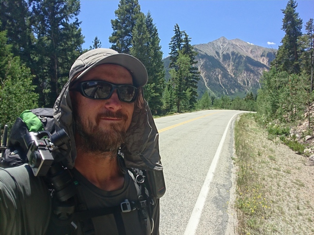
Despite the large number of roads encountered on this stretch, and the lack of a real wilderness feel to it, this one was of the more scenic sections of the CDT in Colorado in my opinion. There were lots of 4×4 vehicles and ATVs out here though. The mountains had a lot of color to them in this section… not just green, but reds and oranges too. Colorful Colorado indeed! Grays Peak and Torreys Peak are also along this route, the highest point along the Continental Divide Trail. 

Tuesday July 3rd – CDT Day 74

Woke up at 8 so I could eat breakfast. The fireside inn is actually a bed and breakfast place with a couple hostel style bunk rooms. Breakfast is a separate charge from the bunk room price, but saves the time of going out somewhere.

I walked to the City Market grocery store after leaving the hostel. I needed a few staple items… Tortillas, cheese, pepperoni, precooked bacon, honey buns and TP. I had everything else already between my Walmart.com shipment to the fireside inn and my left over food from the previous section.

Next I took the bus to the point whew I left trail with Ryan on Sunday. The stop actually is right at the CDT’s junction with CO Hwy 9 which was super convenient. The trail follows a paved road to a vacation home(??) community. It’s weird, the trail goes right through their properties and around a little man-made pond before climbing up some switchbacks. Lots of people coming down.

After an hour I ran into Sprinkler. We hiked the rest of the day together. Rain clouds in the distance, sun coming and going.

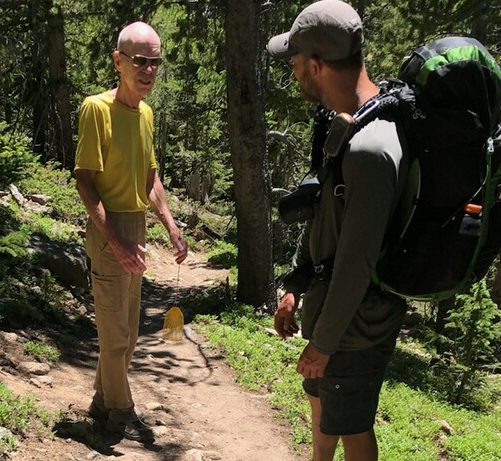
Not much to see today. The trail stays below tree line all day. We passed a guy hiking the Colorado Trail with his two young daughters. Apparently one of them was hit by a mountain biker earlier in the day.

Passed a dog training facility thing… Looked like some giant obstacle course and had a ton of dogs baking. Not camping near that.

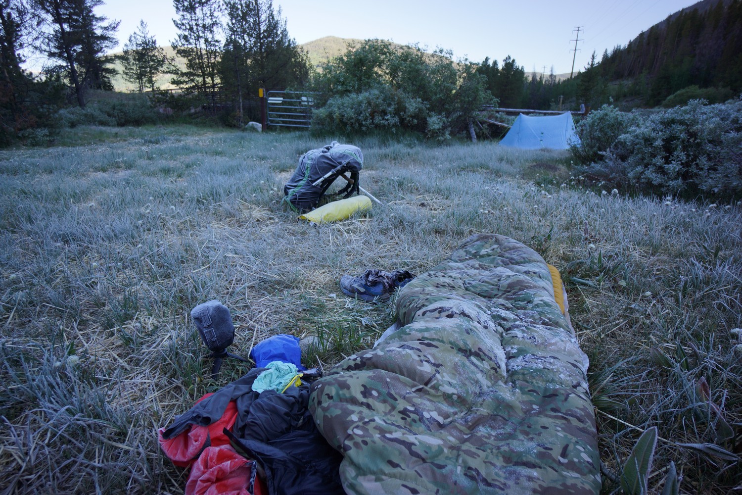
Last water for 20 miles happened to be right before a 2800′ climb. It also started thundering and raining a bit. Needless to say, the decision to camp near the water source was an obvious one, Even if we hadn’t hit our 20 miles for the day. Got to camp at 6pm. Lots of Colorado trail hikers here.

Miles – 16
Total Miles – 1203
Rain – sprinkles
Sleep – Backcountry tent
Animals – Ptarmigan

Wednesday July 4th – CDT Day 75

Sprinkler and I woke up at 5:15am. I figured an earlier start would be best today with the ridge walking and potential for weather.

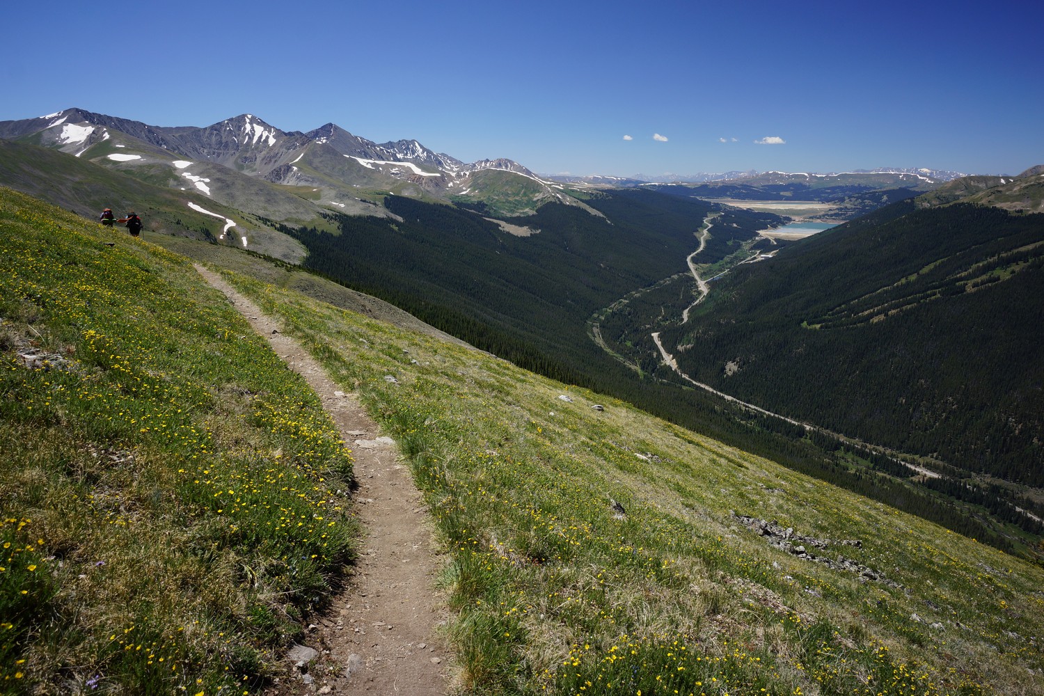
Today started with a 2800′ climb. Typical forest, then emerged from treeline to some colorful mountains.

Sprinkler and I took a break next to some snow fence. There’s a dirt road here that is also the Colorado trail. This is where the Colorado Trail splits off from the CDT, just a couple hundred feet away. Finally, less bikes and people in general. I also saw my first mountain goats here, grazing on the hillside above.

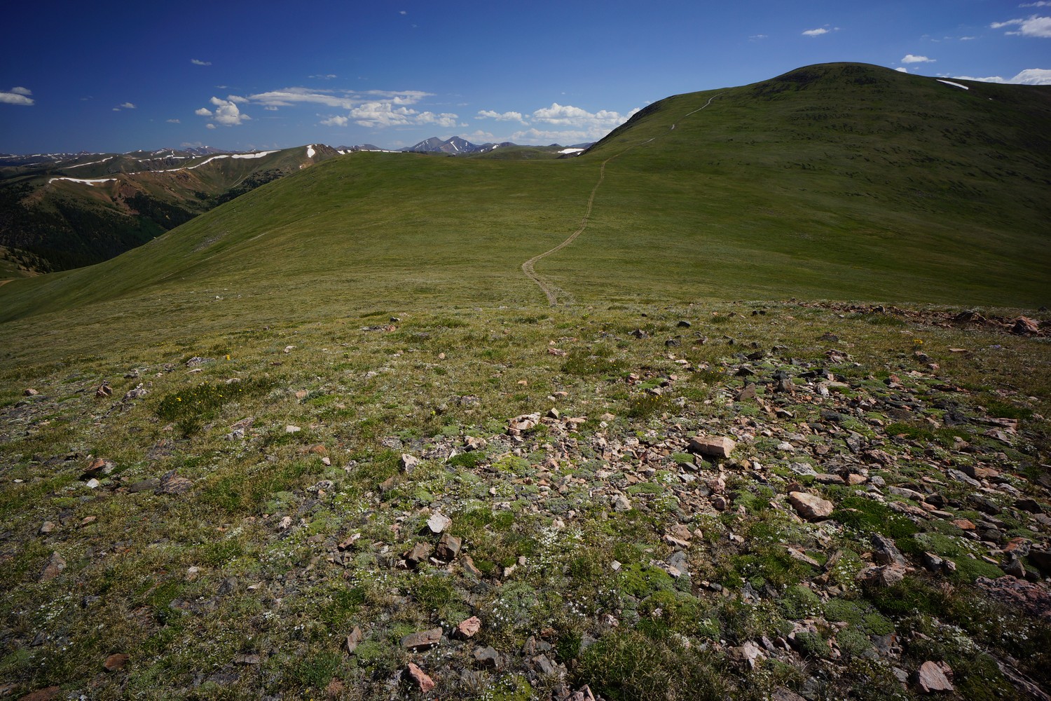
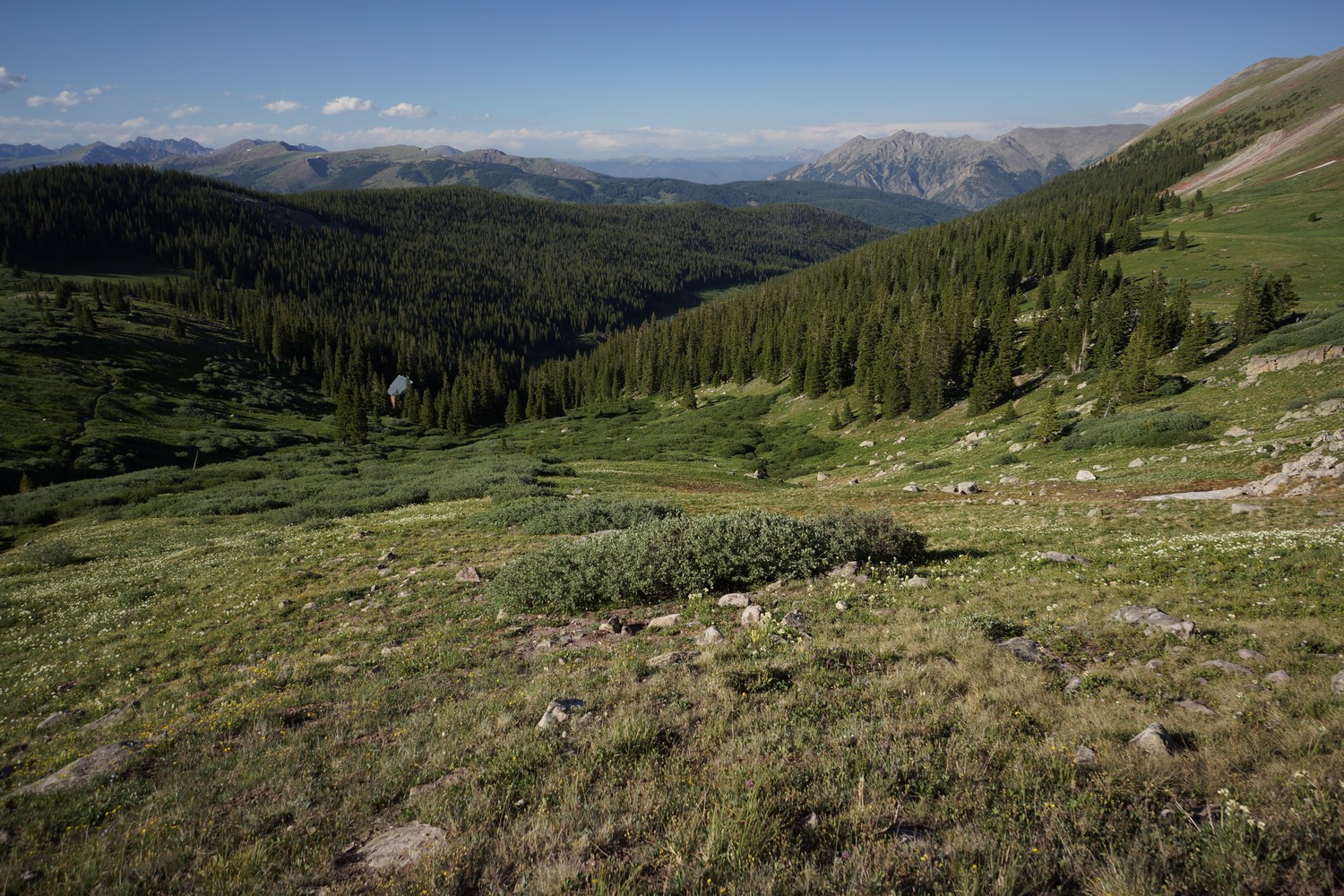
The trail now climbs up along a ridge line. Excellent views all around. Really, some of the best mountain views along the entire CDT thus far. However, the weather was turning. Rain could be seen in the distance for much of the rest of the day, as well as occasional sprinkles on myself.

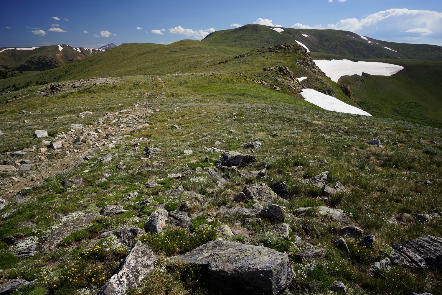
Stopped for lunch along the highpoint at 13,025′. After lunch, we mostly followed some dirt roads. There was a ton of people out here on dirt bikes, ATVs, dune buggies and Jeeps since it’s July 4th.

Hiking up here is hard work. The trail drops a few hundred feet but stays high for a while at over 12,500′. Dark clouds loom and pose a threat, but no lightning to speak of. Such an impressive place to be. 

Rain sprinkles continued on and off throughout the afternoon. There was no shortage of colorful mountains all around. One doesn’t often think of mountains as colorful but they really are here. Lots of reds and oranges compliment the traditional greens. No wonder the state motto is “colorful Colorado”.

At Webster pass, sprinkler and I had a decision to make. Follow the ridge as the CDT route is supposed to, or head downhill and follow a series of roads to the base of grays peak. Considering the bad weather along the ridge, we took the low route. It had already been a long day with a ton of climbing so this was also a welcome choice. However, I know who miss out on a lot of great views. There was no water up there and no where to camp though, so logistically it didn’t really make sense. At least not this late in the afternoon.

We descended the 4×4 road dish to Webster creek as many side by side ATVs were going up. Filtered water at the creek which had a strong iron taste to it. No wonder, it looked a bit rusty. The sprinkles started again as we took our break, cutting it a bit short. Back to road walkin’.

The lower we went, the better the road got. Eventually it turned into a paved road, and even passed through a little town called Montezuma. Just residential homes, vacation homes more than likely. No store to buy a drink or anything. Stop signs were cemented into large barrels along the road. On one sign, Under the word “STOP”, someone had cleverly added the word “hammertime”. Classic.

Then we joined a dirt road along Peru creek, and we bumped into Charlie. Only seen him once before, back in the San Pedro Parks wilderness north of Cuba, NM. He hiked with us much of the rest of the evening.

Sprinkler and I started looking for camp where the trail starts to climb steeply up to Argentine pass, and Charlie hiked on. However, we could not find a suitable place to camp near anywhere below the ascent. Charlie aimed to camp in the upper basin, where it was a little flatter on the topo maps. We filled our water bags at the river and headed up hill towards this area.

When the destination was reached, I was disappointed with the options here. Ground was not flat enough and very lumpy. However, we were tired and it was getting late. This will have to do.

Long day. There’s no way we would have made it here if we took the ridge. Time for sleep.

Miles – 27
Total Miles – 1230
Rain – sprinkles
Sleep – Backcountry tent
Animals – mountain goats, deer

Thursday July 5th – CDT Day 76

Had a little rain last night, pretty light and only lasted 15 minutes. On trail at 7:15am.

From camp, the trail climbs one long path to the pass, angled up the mountainside.

From Argentine pass, the views just got better and better. Lots of ups and downs, tougher as the elevation reaches 13,000.

Stopped for a break before Mt Edwards. It had taken surprisingly long to get here, as it was now 10am or so. We could see storm clouds brewing behind grays peak, so we tried to pick up the pace.

The climb up Mt Edwards was often steep, and filled with false horizons. Great views going up through. Approaching the summit I could see a mountain goat laying down. He got up as I grew near, and limped away. It was pretty obvious he had an injured leg.

Holy crap, the views from Mt Edwards were awesome! Sheer cliffs on one side, grassy ridge on the other. I hiked up the grassy side, so the views were a big surprise.

After Mt Edwards, it’s a pretty gnarly traverse of a knife edge. And it’s not a short section, this goes on for a while. Easily the most exposed, technical section of the CDT so far. But awesome and a lot of fun!

Dark clouds building fast above grays peak. Then a little rain, and some thunder. We were a few hundred feet below the summit and decided to head cross country over to the switchbacks leading down hill and skip the summit. Better safe than sorry.

It rained on and off on the way down. After passing the grays peak trailhead, the weather really started to get nasty. Heavy rain and hail, nearly constant thunder. Fun stuff.

We reached I70 late afternoon. Not much traffic here so we ended up getting an Uber ride into Frisco. We stayed at the snowshoe motel and split a room.

Went to a pizza place and ordered an enormous Chicago style pizza. Meat lovers, of course. The mammal medley. Could only eat half!

Later while walking a street over from the motel, I saw a fox. Only the 3rd fox I’ve ever seen in my life.

The hotel had a hot tub, and I went looking for it. Apparently they converted room 29 into a little spa… Not only the hot tub, but a sauna as well. It was really nice actually. No pool next to it, no kids running around. Relaxing!

Miles – 11
Total Miles – 1230
Rain – heavy rain, thunder, hail
Sleep – hotel
Animals – mountain goats, marmot, fox

Twin Lakes to Breckenridge – CDT Thru Hike 2018

Continental Divide Trail – Twin Lakes to Breckenridge Hike Overview

twin lakes to breckenridge hike on the continental divide trail

Highlights from the Twin Lakes to Breckenridge section of the Continental Divide Trail include Kokomo Pass, an abandoned WWII training facility, Mt Edwards and Mt Massive alternate routes, and a few scenic ridgelines overlooking the ski resorts of Copper Mountain and Breckenridge. North of Twin Lakes, the route isn’t blow-your-mind scenic, but it gradually improves and provides some excellent views. 

Thursday June 28th – CDT Day 69

Woke up at 9 today. Yeah! Slept in and it felt great. Didn’t really mean to though.

Picked up my package from the general store and bought some food there as well. The selection was thin, but with the food I had sent myself in the box I was okay.

There was no where to get breakfast in town so I had to wait until 11am when a nearby food truck opens. Burgers were only 1/3 pound, so of course I ordered a triple with fries. Gotta refuel before hitting the trail, right?

I ate lunch with Sprinkler and Inspector Gadget. Inspector Gadget then gave me a ride back to Willis Gulch trailhead so I could continue hiking where I left off last night.

It’s a 2 mile Road walk along Colorado Highway 82 until I split off the road at Gordon Gulch. My map shows a trail intersecting highway 82, but it’s a private residence here. I walked away from the property by a hundred yards and then headed up hill. It was a steep bushwhack. Then I skirted the hillside above the private residence. I eventually found a faint foot path that led to a dirt road, and eventually a real trail.

Twin Lakes

Lots of people on trail here, as its the base of Mt Elbert. Not much to see, but well maintained trail.

Really hot today… accuweather said 100° for Twin Lakes today! I dipped my hat into streams whenever possible to stay cool. Needless to say, I skipped climbing Mt Elbert. Maybe if I had gotten an early start, which wasn’t possible because of my need to hit the general store this morning.

I reached a trailhead for Mt Elbert close to 6pm. Here I saw several hikers I recognized but hadn’t seen in a while… Namely Marty and Emily, last seen at Doc Campbell’s. Earl Grey’s friend was here with beer and snacks for us hikers. I gladly accepted the beer and hung out here for a while.

After leaving the trailhead, I hiked with Mark and John for a while. This made the uphill climb go much faster.

I found camp on a wooded hill above a small stream after 8. Just under 60 miles to Breckenridge, should be there Sunday.

Warm night, and the mosquitoes won’t quit. Cowboy camping too, should be fun.

Miles – 14
Total Miles – 1139
Rain – no
Sleep – Backcountry, cowboy camp
Animals – none

Friday June 29th – CDT Day 70

I kept my mosquito head net on as I slept for a few hours last night, until the bugs died down. Got up at 6:30, hiking by 7:30.

Dixie adjusting her shoes

Hiked a couple miles and bumped into Dixie. We ended up hiking much of the day together.

Not much to see on trail today. It’s ups and downs in a forest with few distant views, but there were a couple of nice spots. Having someone to talk to made the day go by much faster.

One of the strangest people I met on the CDT

Dixie and I met an interesting old man north of the timberline lake trailhead. He was wearing a bright yellow shirt and only carrying a yellow fly swatter. No water, no backpack, nothing except the matching yellow flyswatter. Let’s just say he was as funny as he looked. And extremely talkative! He didn’t seem to be too fond of the Texans who often vacation here in Colorado.

Passed a couple of small lakes and streams. Eventually entered one scenic basin, nicest of the day.

The trail mostly heads downhill from here, towards Tennessee pass. Not much to see, just a walk in the woods after dipping below treeline.

After Tennessee pass, the trail follows some old railroad grade. I saw Dixie arriving at a campsite, and she offered to share the spot. Sounds good, this is about where I was hoping to camp on my map.

Mosquitoes were insane today. Setting up my tent tonight for safe refuge.

Miles – 25
Total Miles – 1164
Rain – no
Sleep – Backcountry, tent
Animals – none

Saturday June 30th – CDT Day 71

Sprinkler passed camp this morning, and Dixie left before I did. Several Colorado Trail hikers passed by as well.

Most likely these buildings were used to store ammo and munitions

The trail crossed hwy 24 and then followed it on the trees along a hillside. Then it dumps out into Camp Hale, an old WWII training facility for the 10th mountain division. There were signs for possible explosive danger and remnants of the camp itself. Ah abandoned buildings, just like back home in Detroit. Good place for a break.

Then the trail begins a 3000′ climb up to Kokomo pass. It wasn’t crazy steep and was pretty scenic. Passed a small waterfall where Dixie and I stopped for water, and more food. 

Sweet views from Kokomo pass. I stopped here for a while for pictures and did a time lapse with the GoPro. I think this was the first time lapse I’ve done on the CDT. This was disappointing to me, I wish I had taken some in New Mexico at a few spots.

The trail then climbs a little more to another great view point. Then it stays high in a basin for another 3 miles towards Searle pass.

I stopped on Searle pass for a while as well. All down hill from here.

Really nice hike this evening down to Copper mountain ski resort, at the bottom of the valley. I caught up with Dixie again, and we hiked the rest of the way down together. We discovered a restaurant that serves food until 9pm, so we hauled ass down to make it in time.

At the restaurant, we ran into Steve, a guy we met on trail earlier this evening. He offered to let us stay at his place in Dillion tomorrow night when we’re in his neck of the woods. Also, an older man bought us a round of drinks after over hearing our journey on the CDT!

After dinner, we road walked through town in the dark over to Tenmile creek. We found a place to camp near the river around 11pm. There were a couple of people who passed by in dark and shined their lights on us. One guy was hiking and kept going. The other was a biker. He shined his light directly on my face for like a minute. I shined my light back to let him know I was there, but he didn’t turn off his light. Finally, I said “hey, could you not shine your light in my eyes? trying to sleep here.” Then he finally left, without saying a word. WTF is wrong with people!

Miles – 26
Total Miles – 1190
Rain – no
Sleep – Backcountry, tent
Animals – marmot

Sunday July 1st – CDT Day 72

This is why I generally don’t like camping low, near rivers… Cold and tons of condensation. Frost on my bag and everything.

Late start, about 9:30. Steep at first. A lot of mountain bikers today.

After reaching tree line, the trail became less steep. Now its angling up to a ridge line with great views.

On the crest of the ridge, it’s copper mountain on one side and Breckenridge on the other. Man, I gotta get out here in the winter and ski.

Nice views coming down above tree line. I just talked to my friend Ryan, he was almost there at the Gold Hill trailhead along Colorado Highway 9. He said he was going to start hiking uphill and that way I would meet him on trail as I was coming down hill. Time to hurry my ass up.

For whatever reason it was fairly slow going this afternoon. It took a little bit longer than I expected but eventually I saw him hiking uphill with his dog Yogie. We turned around here and headed back to the trailhead where he parked. I noticed a forest fire burning off in the distance from here as well. 

After reaching the trailhead we headed into Breckenridge for food. I had been told Empire Burger was excellent, so that’s where we headed. The biggest burger they had was a double so I added another Patty to make it a triple. The waiter said it was the largest Burger he’d ever seen anyone order, although it was only one pound. And it was delicious!

Afterwards we got a hotel in Silverthorne that was pet friendly. We tried going out to a couple breweries but none of them had a pet-friendly patio so we headed back to the hotel. Luckily the hotel had a hot tub and I enjoyed a nice soak.

Miles – 13
Total Miles – 1203
Rain – no
Sleep – hotel
Animals – rabbit

Monday July 2nd – CDT Day 73 (zero day)

Wish I had more time to sleep but we got up early for breakfast. Ryan also had to leave town by 8am.

Ryan dropped me off at the Fireside Inn hostel after breakfast. This is where I initially had planned on staying. It was a little after 8am. so I was pretty early. They let me set my backpack inside the garage and I went out and wandered the city for a couple hours until they had a chance to accommodate me. I went into a couple of souvenir shops as well as fly fishing shops to pick up some stickers and things for my dad.

Later in the day I walked up to the post office and mailed back all of my rocks I’d been collecting, as well as the stickers and souvenirs I just bought for myself and my dad.

Afterwards I headed up to REI in Dillon. The summit stage bus system is free and provides transportation in the Frisco, Dillon, Silverthorne, and Breckenridge areas. However. It was a little complicated, at least for someone who has never used public transportation before. It just doesn’t exist in Detroit… You get in your own car and go wherever you want. After realizing it was going to take a very long time to get there, with all the bus transfers and things, I just got out at one of the first stops and picked up an Uber for 15 bucks.

At REI I bought a new pair of shoes, brooks cascadia 13s. This is the first time I’d seen them. I’ve been using the 12s on trail to to this point. I liked them initially but will carry my old pair until they prove themselves. I got 650 miles of of the first pair of 12s and 550 miles out of the second pair. However, I could have hiked more miles in the 2nd pair, I just decided to get them now while it was convenient.

I also picked up some sawyer permathin bug spray for clothes and gear. The mosquitoes have been so bad, I’ll try anything… Except bug spray. Don’t want that on my sleeping bag!

I tried using the bus again after leaving REI. Big mistake. The stupid bus drove around for an hour and a half without ever going to the stop I wanted in Silverthorne as the map indicated it would. I eventually got off after an hour and got an Uber again.

For dinner I ate a large pizza from a place called “extreme pizza”. It was good but there was nothing extreme about it.

Bed by 10. Will get back on trail tomorrow, after breakfast and stopping at the grocery store.

Miles – 0
Total Miles – 1203
Rain – no
Sleep – hostel
Animals – none

CDT Blog Posts Postponed Until Hike Completion

I have decided to hold off on posting CDT hike updates while on trail for the sake of time. It takes the better part of a whole day to update the blog with 2-3 posts, and I am spending more time than I should on a computer in town. I need this time to do chores (laundry, groceries, gear repair, etc), and have been taking extra days off in town just to complete my blog updates. Extra days in town means more money spent, and lessens my chances of making it to Canada in time before the weather turns. 

I will still be keeping a detailed journal throughout the rest of the hike. When I return home in the fall, I’ll complete my blog updates for the remainder of the CDT. Thank you all for your support and understanding. 

×