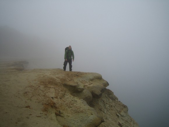
Backpacking Pictured Rocks National Lakeshore, MI – June 2011
Pictured Rocks Backpacking Overview
Complete Pictured Rocks Photo Gallery
- Location – Pictured Rocks, Michigan
- Park – Pictured Rocks National Lakeshore (National Park)
- Trail Hiked – North Country Trail
- Miles Driven To Destination – 820 miles Round trip
- Length Of Time Hiked – 5 days, 4 nights
- Trail Type – Point to point
- Miles Hiked – 42.5
- Trail Difficulty – 2.5/10
- Fires Allowed – Yes (in designated campsites only)
Pictured Rocks is one of the premier backpacking spots in Michigan. I had never been here and decided it was about time I go, but I didn’t have anyone to go with. I was planning this trip solo, but at the last moment my buddy Jesse decided to go with me. Literally, 12 hours before I left! I had extras of everything except a tent. This we would pick up on our way there.
Notes
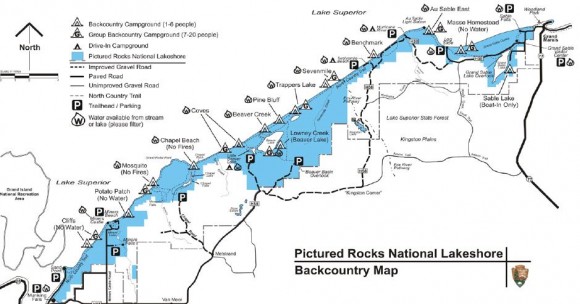
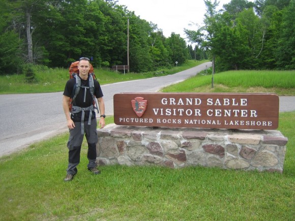
Pictured Rocks is a point to point trail, and requires the use of a shuttle bus, second vehicle, or someone else picking you up and/or dropping you off. For most, the shuttle bus is the most convenient, and this runs you $20 per person, one way from Musnising Falls to the Grand Sable visitor center, or vice versa. Prices are as of June 2011.
To camp at Pictured Rocks, you need to reserve your campsites in advance. You can do that here: http://www.nps.gov/piro/planyourvisit/upload/BackcountryReservationForm2011.pdf
There is a fee of $5 per night, per person due when you pick up your permit. You can pick up your permit at either end of the trail, Grand Sable or Munising Falls. Their locations are below:
Interagency Visitor Center – Munising Falls
400 East Munising Ave
Munising, MI 49862
906-387-3700
Grand Sable Visitor Center
E21090 County Rd H-58
Grand Marais, MI 49839
906-494-2660
Day 1 – Monday June 20th, 2011
Miles Hiked – 7.1
Route – Grand Sable visitor center to Au Sable Point East
We stayed the night at Jesse’s sister’s place in Marquette the night before, and Munising was just a short 1 hour drive away from here. Once arriving in Munising, we stopped at the visitor center at the intersection of M-28 and H-58 to pick up our permits. Then it’s a short drive over to the parking lot, a few hundred yards away. Here we unpacked our gear from the car and made some last minute changes, and took our frozen foods out of the cooler and packed them with the rest of the food. We had burgers and italian sausages frozen, which would thaw slowly enough to make these possible for nights one and two’s dinner. I was trying out my new OP Saks as well, which are supposed to block the scent of your food so that animals cannot detect them. I guess we’ll put them to the test here.
Today was pretty cloudy and cool. The weather all week was not looking good… rain and cool temps throughout the week. The temperature right on Lake Superior can be drastically cooler than being inland only a few hundred feet due to tree cover. Being right along the lake, I knew it was going to be cold at times.
By the time the shuttle arrived, there was a large group of hikers ready to board. I’d say 20 or so… not what we wanted to see. The ride to the Grand Sable visitor center takes about an hour, maybe a little less. Once off the bus, people scattered and went their separate ways. We went into the visitor center to fill up our water supply before heading out. By the time we hit the trail, about half the people had left in front of us. The leg of the trail goes straight into the woods from the visitors center, only to pop back out less than a mile away. Now, you follow the road we drove in on for a ways before heading back into the woods. We must have missed the sign for the trail on the road because we kept hiking the road for what seemed like a long time. Finally, there was a section of the trail that curved close enough to the road that we saw other hikers on it and realized our mistake, and jumped back on track.
The trail then wanders through the trees for another mile or two before you see a small trail intersecting the main trail, heading North towards Lake Superior. Upon further investigation, we realized this trail takes you into the Grand Sable Dunes. We dropped our packs went exploring through the dunes for a while. We found many wild strawberries here, although they were very small. This was a very cool place to check out along the trail if you have time. I wish we would have hiked around a little more through here but we wanted to make sure we got to where we needed to in time today, so before long we were back on the Lakeshore Trail.
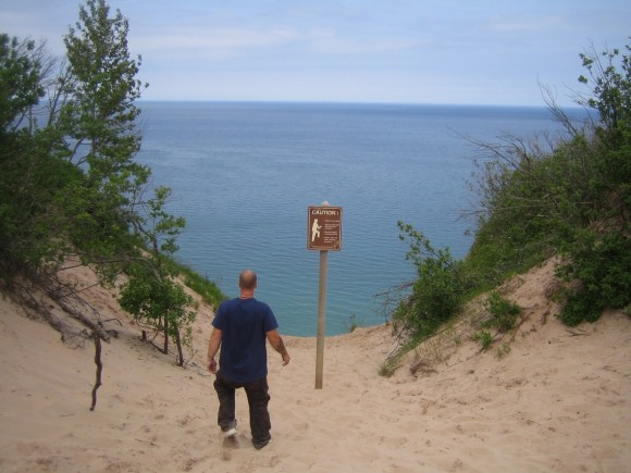
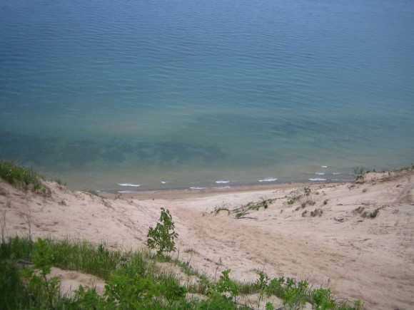
Not much farther, we encountered another cool area called the Log Slide. Back when this area was being logged, they would slide trees down the side of this 500ft dune straight into Lake Superior. This was MUCH higher than it looks in the pictures, and offers on of the best views on the East side of the Lakeshore Trail. There was a guy at the bottom of the dune who was trying to climb up the entire time we were there, and it didn’t look like he made any progress at all. We stopped here for another 20 minutes or so before continuing along.
We weren’t far now from of campsite at Au Sable Point East. Throughout the day, we saw several hikers in multiple groups, many if which were not on the shuttle with us. There were so many people we didn’t bother counting. Once we got to our destination, we found that the campsite is really more of an area with multiple campsites that are on a first come basis. There were already a few other groups of people her who had taken the best spots, but ours was decent. Just no real privacy here, it seemed like people were all around you. Shortly after setting up camp, a forest ranger came through here on foot checking permits. He told us he had seen a bear earlier today, I believe by Kingston Lake.
We had a few hours left before sundown, so we decided to hike over to Hurricane River and try fishing. This was about a 1.5 mile hike each way from Au Sable Point East. About halfway in between Hurricane River and camp is Au Sable Point, a lighthouse and what seemed to be a museum of sorts. There didn’t appear to be anyone here, nor was anything open. Another 15 minutes past the lighthouse is the river, which we fished for about an hour tops. After getting chewed up by mosquitoes and having no luck, we headed back, ready for dinner. We headed down to the beach to find a place to cook, and found a large rock in the sand that would block all the wind if we cooked behind it. The burgers came out crispy on the outside and raw inside, but still pretty good.
Day 2 – Tuesday June 21st, 2011
Miles Hiked – 11.8
Route – Au Sable Point East to Pine Bluff
Dark clouds lingered offshore as we awoke Tuesday morning. We were pretty sure it was going to rain, so before leaving camp we put on our rain gear. It was pretty cold out too, so the extra clothing wasn’t a problem. Having already hiked the next 1.5 mile section of the trail last night on our way to and from Hurricane River, we decided to hike along the shore of Lake Superior. Although it was a little slower going, there was more to see here than back on the trail itself. Lots of cool rock formations along the beach and submerged in the water. We stopped to filter some water in a calm pool on the beach which was much easier than standing on rocks that protrude out into the Lake as we attempted last night. With a full supply of water and full stomachs, we were ready to cover some ground. Today we’ll hike 12 Mile Beach in it
Once we reached Hurricane River, we jumped back on the Lakeshore Trail and continued West. It started to rain around this time, and continued to do so on and off until the day we left. My rain gear was all new, and this was the first time I had a chance to wear it. I bought Outdoor Research Revel rain jacket and pants after reading some good reviews. Jesse made the mistake of wearing cotton clothing, because that’s all he had before we left home. For rain gear he used a set of Frogg Toggs, XL size. However, after it started raining he failed to put his hood on, and as a result all of his clothing ended up getting wet underneath the rain gear.
Since it was raining, we were moving fairly fast as there was no point in stopping. Before we knew it, we were crossing Seven Mile Creek. The way these rivers dump right out into the Lake is pretty cool. These river mouths seemed to twist and wind before actually running out into the Lake for some reason. We had a brief break in the drizzle now, and we took a minute to hang out near the creek and take a quick rest here. We found a snapping turtle under a log, handle was a pretty good size. We joked around about wanting to eat him, then it was back to the trail. Not long after this, we saw a bald eagle fly over head as well.
The section of trail we were hiking on today was known as 12 mile beach. I’d have to say this most boring day of the entire trip. The beach is literally 12 miles long, and there’s not much to see here. Due to the rain, we didn’t leave the trail at all really, just tried to keep moving. The beach didn’t look particularly interesting here, but we also didn’t take the time to check it our either. Towards the western end of 12 mile beach, you enter the Beaver Basin Wilderness. This section was much more wooded and a nice change after what seemed like a long stretch of shoreline.
At one point, we came across an old car in the middle of the woods. It looked like there used to be an old single track road running through here, but that must have been a long time ago. About halfway through the Beaver Basin Wilderness we reached our campsite, Pine Bluff. There was one other campsite taken by 2 guys, but the rest were empty. We set up camp as it sprinkled, and were basically confined in our tents for the rest of the evening due to the constant precipitation. What made this worse was that today is the longest day of the year, so the sun is up until around 10pm. I find it hard to sleep unless it’s dark out, so I laid awake for hours before being able to fall asleep.
Day 3 – Wednesday June 22nd, 2011
Miles Hiked -7.1
Route – Pine Bluff to Chapel Beach
It was raining when we woke up today. It was also pretty cold out, definitely in the 40s, so getting out of bed was a real challenge. My shoes and socks still completely soaked, so putting those on sucked to say the least. Finally out of the tent, it was still raining so I worked fast to pack up my tent and get ready.
Jesse actually had it worse than me though. When we bought his tent on the way here, we accidentally bought him the “Junior Scout Tent” for kids. Not only did he have to sleep in the fetal position, but he woke up with a LOT of water inside his tent. Now, everything he had was soaked, including his sleeping bag and all clothing. His cotton clothing was doomed after this, and he stayed wet for the remained of the trip. I was mostly dry, except my feet. The Merrell Moab Ventilators I wore were a bad choice in footwear for this trip, but there was nothing we could do now except keep moving.
It rained throughout the morning as we hiked our way through the Beaver Basin Wilderness. We passed what we thought at first to be a small cave, but was more of an overhang in the rock, really. We decided to take shelter in here so we could get out of the rain and cook lunch. Since it was raining last night, we didn’t cook our italian sausages as planned, and they were completely thawed out by now. Being frozen until hitting the trail, and then insulated in my backpack with these cool temps, I wasn’t worried about it being safe. Plus, I have an iron gut!
Wouldn’t you know it? As soon as I started cooking, the rain let up. This was nice because we got a chance to explore around this area for a little while after eating. I climbed up to the top of the rock formation for the hell of it. Finally, it wasn’t raining!
Back on the trail, the landscape started changing. Now, there were picturesque beaches and cliffs around every turn. We saw a few waterfalls pouring right into Lake Superior. With all the rain, they were gushing in spots that probably were barely a trickle normally. I really wish the weather would have been nice and sunny, as it would have been fund to explore off the trail here. I could still see rain clouds offshore and it always looked like rain wasn’t far away. We passed Chapel Rock and took some pictures, but were eager to get to to camp and we knew we were close.
By late afternoon, we had reached Chapel Beach, our campsite for the night. There were no other people here to share camp with today. The weather was teasing us with brief moments of sunshine, so we hung our clothes and sleeping bags from the trees to dry them out after getting the tents up. These campsites at Chapel Beach were nice, compared to the others we stayed at. Our site was perched right above a river, Chapel River I believe. We tried fishing it for a while before giving up. We then decided to go down to Chapel Beach and check that out before it decides to rain again. While getting ready to g to the beach, the temperature felt like it dropped 20 degrees at once.
Once down to the beach, it looked like the fog was starting to roll in. It was very cold, there was a frigid wind coming off the lake. This was going to stop us from enjoying the beach, just from swimming. We walked over to the point where Chapel River pours into the Lake. The water temperature of the river felt 20 degrees warmer than the air, and looked like it had steam or mist coming off it. We crossed the river and got some pictures from the other side, as well as some photos of the 6 foot swells crashing on the rocks near the shore. We then walked over to the West side of the beach and sat down for a while to take it all in. By the time we left to go back to our campsite, the cliffs on the West end were completely engulfed in fog. This fog never lifted until our last day.
Day 4- Thursday June 23rd, 2011
Miles Hiked – 11.3
Route – Chapel Beach to Cliffs
When I woke up, it was not raining at the moment but had been on and off throughout the night. Everything was still wet, and it was another fun morning putting on cold, wet shoes and socks. Once I got moving though, my feet were fine for the rest of the day. The cold goes away and you just get used to having your feet completely soaked after a while. We didn’t bother stepping around puddles anymore, there was no point. My gaiters seemed to help a great deal keeping the debris out of my shoes though, so they weren’t too muddy, just wet.
Today’s hike, along with yesterday’s, were the coolest part of the hike for both of us. This is the area where all the tour boats come to see the cliffs and colorful rock formations. I can only image how beautiful it would have been on a sunny day. The fog was extremely thick today, sometimes only a few hundred feet at most for visibility. This made it impossible to get any long distance pictures.
Just West of Chapel Beach is Grand Portal Point. On the trail, we were looking north through a clearing in the trees and saw a wide open area filled with fog. It was a flat, rocky area that suddenly drops a few hundred feet straight down into Lake Superior. At times the fog was so thick that I couldn’t even see the water below! After a few pictures, we hit the trail again. There were several other scenic vistas along the way, and we stopped for most, even if only for a minute or two.
The next noteworthy area we encountered was Mosquito Beach. I’m glad the foul weather was keeping all of the bugs away, because I didn’t care to find out if this beach lived up to it’s name. Hey, there’s ONE good thing about this weather! We hiked the beach, which really just a series of rocky plates and ledges, until we found a cave at a point. Inside were two people having lunch. They said we could join them, in the cave, so we stopped to eat lunch as well. It was a mother and her son, the mother was actually a geologist and was telling us about the formation and history of this “beach”. They left shortly thereafter. We walked down the beach Westward and encountered Mosquito River pouring into the lake. This wasn’t as spectacular as some of the other rivers though.
It was mid afternoon now and the fog still had not lifted. Hiking through the mist filled forest was eerie but very cool at the same time. We passed many more overlooks that were blocked by the fog, and we were left to imagine what could have been. Between Mosquito River and Miners River, we began to hear the roar of a waterfall in the distance.Eventually the trail led us to a 30 foot waterfall which we were able to walk behind.
As you near Miners River, the trail runs close to an open beach. We stopped to check out a small stream that was gushing water out onto the beach. It was flowing over a rock ledge, creating a 6 foot waterfall. Just a little farther down the trail and we reached Miners River. This was a larger, deeper looking river than the others we’d seen so far. It looked very promising to fish, so we stopped to try our luck. I threw in a few casts before giving up. While Jesse fished, I followed the river to it’s mouth. The river was 50ft wide in spots, and ended up pouring into Lake Superior through a 4 foot wide channel, carved between the beach and a cliff.
It was raining on and off throughout the afternoon, and as Jesse was fishing it started again. Shortly after leaving the river, the trail goes through the Miners Castle Overlook area. There were a handful of people here, but with the fog you still couldn’t see very far. There is a paved parking lot here, along with nice restrooms. It was raining fairly hard here, and we tried waiting it out under the awning for a few minutes before it died down and we were on our way again.
The cliff’s campsite was not much farther from here, we made it in a half hour or so. It was just us here again tonight, which was fine with us. Nobody was out here in this weather but us. It rained as we set up our tents, and didn’t stop all night. We wanted to cook hot dogs tonight, but the relentless rain trying to thwart our plans. We had one extra poncho, and I had an idea. We found a spot under a tree that we could rig the poncho up as a makeshift tarp to cook under. This poncho was small, and we could barely fit underneath it. We also had to tip water off of it every so often so that it would not either drip on us, or collapse the entire thing. But, this got the job done and it was nice to have a hot meal. It was also nice not being confined to the tent, at least for a little while. Then, it was back to the tent again. It rained the hardest and most frequently tonight of any time we had been here.
Day 5 – Friday June 24th, 2011
Miles Hiked – 6.4
Route – Cliffs to Munising Falls
We were both ready to go home when we woke up this morning. One last day of cold, wet shoes. For Jesse, everything he had was soaked completely.It wasn’t raining so we made the best of our time and got on the trail quickly. Like I said, we were ready to go home. We had been talking about getting a meat lover’s pizza when we get back home, which was now just a 6.4 mile hike and a 7 hour drive away.
Most of the exciting scenery had ended yesterday around Miners Castle, and the trail was relatively boring now at this point. We did pass a few small waterfalls, but nothing spectacular. The fog had mostly gone today and now visible for the first time was Grand Island.Past Sand Point, we saw a crew of volunteers repairing a bridge over a small stream crossing. We knew we were close now. I was feeling fine physically, but Jesse was getting pretty tired. Only a mile or two from the parking lot now, we saw a deer. She was about 50 feet away, and we became very still and quit as I pulled out my camera. The deer actually started walking straight towards us. She then began to circle us, but we remained still and got a pictures.
We were back at the car around noon, and first thing we did was change out of our wet clothes. The bathrooms were under construction, so we changed in the parking lot.
Across the street was “Dog Patch Restaurant”, which we ate at for lunch. This place had a weird theme of old country folk cartoon characters all over the walls. A burger and fries hit the spot, and we were on our way back home, looking forward to the traditional post hike pizza!
Final Thoughts
I feel like I really got screwed with the weather. While the fog of day 4 offered some unique photo opportunities, I was hoping for a sun filled week with amazing sunrise and sunsets. Oh well, you can’t win ’em all.
My rain gear did an excellent job of keeping me dry, and If it weren’t for my poor choice in footwear, I might have stayed completely dry the whole trip.
This is a pretty easy hike. There is very little ups and downs, and none of them are steep. This would be a great place to take inexperienced hikers or those who want to do a long hike but might not be prepared for more challenging locations. There is almost no need for a map and compass here, the trail follows the Lake for 42 miles. Simple.
I highly recommend this hike! There is a lot to see here, so plan extra time for side trips.
As always, questions and comments are welcome!
If you found my trip report useful, please don’t hesitate to leave a comment! Alternatively, if you feel you have any information you’d like to share with others regarding this hike, please feel free to leave that below in a comment as well.
[tcb_comment_count]

