Creating new thru-hiking routes & guides, hiking videos, outdoor documentaries, backpacking trip reports, trail journals, photos and more!

Latest

Lincoln to East Glacier – CDT Thru Hike 2018

Continental Divide Trail – Lincoln to East Glacier Hike Overview

I entered the Scapegoat Wilderness just north of Rogers Pass, where I did the most climbing I’d done in a single day on the entire CDT. However, these were the best views I’d seen in a long time. Lots of ridges with distant views. Then the trail drops down into a valley, where it’d mostly stay for the remainder of the hike to East Glacier. I picked up a package of food I had my dad send to Benchmark Ranch along the way before starting the Bob Marshall Wilderness section. Forest fires and high elevation snow forced a lower route through the Bob, so we missed the Chinese Wall and more. Winter is coming soon. 

Friday September 21st – CDT Day 154

Woke at 7:30. Took my last hot shower for the next 8 days. Then we all went out for breakfast at Lambkins.

Gary, the local trail angel, picked us up here and took us to Rogers Pass. Near the pass was a sign for the record cold spot in the Continental US at negative 70 degrees. Wow!

The trail starts climbing right away and does so all day, really. Passed a locked yurt about 3 miles in. It’s used by some guys doing research on eagles and stuff. It used to be open to hikers from what I heard.

Wow, lots of climbing today. However, this time there is a reward of nice views from exposed ridgelines.

So many ups and downs. It was a tough day. Almost no water sources as well.

Hiked to 8:15 and found camp on a flat but exposed section of a ridge. We cowboy camped, figuring no rain tonight. With a 10:15am start, we were hoping to get more than 22 miles today. There was just so much climbing. Today was actually the day with the most elevation gain on the entire CDT for me at 7576′.

Miles – 22
Total Miles – 2675
Rain – no
Sleep – Backcountry, cowboy camp
Animals – none

Saturday September 22nd – CDT Day 155

I slept great until about 1:30 this morning. Then the wind picked up. This was a nuisance until I got up at 6:30.

We continued up the Ridgeline we camped upon last night. Great views for the next several miles. The winds remained strong and tossed us around as we walked.

After a couple miles of hiking the trail drops down into a valley along a Creek. This was a Welcome relief from the maddening winds. The boring forest I cursed for the last several hundred miles was now my sanctuary.

The trail trends uphill for several miles at a decent grade. Yesterday was the first day of fall, and today that is apparent with the colors changing on select trees.

We then hiked up over a pass above welcome Creek. For a couple miles before and several miles after the pass, we hiked through old forest fire burn areas and blow downs.

We found camp at the junction where the CDT splits off from Straight Creek around 7:15pm. The sky was dark and had already let loose a few sprinkles, so it seemed like the right call to make. I nestled my tent among some trees to provide protection from the wind and potential rain. Good day of progress!

Miles – 28
Total Miles – 2703
Rain – sprinkles
Sleep – Backcountry, tent
Animals – none

Sunday September 23rd – CDT Day 156

Nice night… Calm, no rain and not too cold. Woke at 6, hiking at 7.

Patches of dark clouds rolled by as we left camp, but cleared up as the morning went on. The burn area continues down this valley for another mile or two. Finally, we are in living forest again!

We made good time to Benchmark. At the road junction, I headed to the benchmark wilderness ranch and hopeful hiked to a trail junction we agreed upon. He isn’t picking up a box here, so no need for him to walk extra miles.

The benchmark ranch was empty when I arrived. It wasn’t clear where the CDT resupply boxes are stored, so I started poking around. Found it… Front porch of one of the “main” cabins. There was even a trash can for all my garbage. In years past I’ve heard there was no trash can, and so you had to pack out all garbage.

I left benchmark and hiked to a trail junction hopeful and I agreed to meet at. The fall colors were beautiful here. Mainly, the aspens and their golden color. They’ve really come out in the last few days.

Hopeful and I hiked north on the South fork Sun River trail after reconnecting. This was definitely a main thoroughfare, with tons of horse traffic. Nice views of the river.

Reached West Fork South Fork Sun River and crossed our at a large bridge. Yep, super long name and it sounds ridiculous. From here, we’d continue west to say on the CDT. But since we need to reroute around the Juliet fire and Moose creek fire anyways, we decided to continue north on the south fork sun river trail. This will reroute around the fire while shaving off a few miles.

The south fork sun river trail was really beautiful. Lots of big views of the river, fall colors and mountains.

Easy walking along a flat river valley that was dry, not swampy. Really, a rare combo!

Right before we found camp, we bumped into a herd of about 15 elk in a field. There was a big bull a hundred yards away, and others putting on a vocal show further along the tree line.

We made camp in the tree line not far from the elk. They were perfectly happy being super vocal all night with us here. They were doing their thing, we were doing ours. Man and beast, living in harmony.

Miles – 29
Total Miles – 2732
Rain – no
Sleep – Backcountry, tent
Animals – deer, bald eagle, elk (around 15)

Monday September 24th – CDT Day 157

Slept great. The elk were bugling all night, heard them every time I woke up. Sounds like a cross between a horse and a dinosaur that’s being murdered.

Started hiking just after 7. The clouds look menacing today, very dark and low.

Saw lots of fresh grizzly scat this morning, even some prints.

Low clouds rolled into the valley and gave us some sprinkles. Higher elevations were getting snow. With the fall colors and snow capped peaks, it looked like an iconic western art scene.

Reached gates cabin early afternoon. This looked to be a Ranger outpost. There were a few horses in the corral, but the place was locked up. Probably out for patrol. Either way, the porch was a great spot to eat lunch and get out of the rain.

Gates cabin was near the junction with the CDT, where would rejoin after the fire reroute. However, it looked as if we could take another shortcut by continuing north along the north fork sun river trail. This would keep us at low elevation and out of the bad weather up high. It would cut off a few miles as well. Only problem is, we don’t have a map showing the trails north of a certain point. Despite this, we were confident there would be a trail here that would eventually take us back to the CDT.

Our alternate route was definitely not as straight as we hoped. There were many zig zags and a few trail junctions that we basically guessed at. There were also a couple river Fords. Man, that water is cold!

Early evening we heard several wolves howling not too far away. That was cool to hear. We then stumbled upon a horse camp with a ton of wooden “improvements”, mostly to corral and otherwise support the housing of horses. There was also a lot of wood cut and ready to go for a fire. This is the obviously place to camp, since we were thinking a bushwhack might be necessary to rejoin the CDT at this point. That’s best left for the morning.

We had a nice fire, I think my 5th on trail. Got in my tent second before the sprinkles came back. Perfect timing.

Miles – 23
Total Miles – 2755
Rain – yes
Sleep – Backcountry, tent
Animals – deer, elk (around 15)

Tuesday September 25th – CDT Day 158

It rained fairly heavily last night. Woke at 7am and it still looked crappy out when I poked my head out of the tent. Since we’ll be bushwhacking through wet vegetation in the cold, we decided to wait a while to see if the sun comes out. Would be much nicer if it were warmer and drier.

Hopeful had a fire going when I woke up at 8:45. Three was patches of blue but clouds still dominated the sky. We didn’t start hiking until 10:15ish.

We back tracked a couple hundred feet until we reached a trail going down to a campsite along the river which we passed on last night due to it being a magnet for condensation. The trail led to a campsite, indeed, but it also crossed the river, which we could not see from the trail above. On the other side was a trail junction with signs. This led us to the North Fork Sun River trail, number 110. We were on this Trail initially after leaving gates cabin yesterday, but it seemed to branch off into trail 109. It would have been nice to have maps showing where these trails went, but we didn’t have that luxury. We went fairly far out of the way following trail 109 compared to where 110 would have run. Either way, back on trail and no horrendous bushwhack! Best case scenario.


Hiked several miles through burned areas and downed trees before rejoining the CDT. I was having a rough morning, just really wanting this hike to be over. Still another week or so and about 175 miles.

Took lunch by a stream. Laid my tent in the sun to dry, filtered water and washed my socks. It’s so great to not be moving. The entire day is spent hiking, from sun up to sun down, and this just wears on you mentally after a while.

Most of the rest of the day was spent hiking through burned areas, with occasional patches of forest that was spared. Had to ford strawberry creek, which was cold but shallow. Weather was gradually clearing but still lots of puffy white clouds.

Stopped to eat a quick dinner around 6. Then we pushed on for another 4.5 miles to a guthook waypoint with comments about a good campsite. Arrived at 7:40, just as it was getting dark. 22 miles today, not bad for a late start. It was a clear night now and the stars are out.

Miles – 22
Total Miles – 2777
Rain – yes
Sleep – Backcountry, tent
Animals – deer

Wednesday September 26th – CDT Day 159

Got up at 6:45, and it was cold. There was condensation on the inside of my tent, which turned to frost as soon as I opened it. There was a full moon still illuminating the sky, making it much brighter than daylight alone would have.

Hiked through burned out forest for a while. Some of the wooden trail signs had burned, but were still readable. Sort of.

The trail then made its way around a few small lakes. We stopped at one of them for first lunch. Found a spot in the sunlight on a open grassy slope high above the water. Here we could dry our tents out while eating. When I opened mine to lay it out, there was so much frost that it collected into about half a snowball which I then threw at hopeful. While sitting here, a guy named Goldilocks stopped to chat with us. I believe hopeful and I have both met him at separate times further down the trail. At Old Faithful he flipped up to Glacier and hiked the GDT(Great Divide Trail), and just now heading south back to Old Faithful.

After lunch, the trail continued through some healthy forest. Finally something that’s not burned. In fact, lots of the vegetation along the trail was overgrown. Easy walking though.

It was actually pretty warm today, and the skies were mostly blue. A nice change from the last couple days. I hope the weather can hold out another week like this.

Stopped at a stream for a second lunch. We were almost at a junction where the CDT climbs 1500′ and jogs sharply west. There’s an alternate route that continues straight and cuts off about 4 miles, as well as the climbing. That’s what I wanted to do. Hopeful wanted to climb it. Additionally, Hopeful was shooting to get into East glacier Friday morning whereas I prefer to get in tomorrow, Thursday night. We decided to split up at this junction and do our own separate thing, meeting up Friday morning in East Glacier.

After second lunch the trail became much wider, akin into the south Fork sun Trail just north of benchmark a few days ago. You could drive a car down it. I passed a ranger outpost cabin which looked like no one was home. Other than that, just a walk in the woods.

I stopped at a really nice campsite around 6:45. I’d planned on hiking a few more miles, but the trail will drop down into a river valley and I thought staying higher and drier would be the way to go.

Miles – 26
Total Miles – 2803
Rain – no
Sleep – Backcountry, tent
Animals – none

Thursday September 27th – CDT Day 160

Woke at 6:30. Slightly warmer this morning, but cloudy. Looks like rain.

The trail crossed the south fork two medicine river several times. No bridges, no obvious crossing points… Had to really hunt for a spot to hop rocks and logs. Even then, it wasn’t easy. In the end, my feet got wet when they slipped off rocks. Then I just walked through the water for subsequent Crossings.

It was raining lightly as I made my way down the river. As the trail nears hwy 2, it becomes more of an old road than trail. There were gates and barbed wires fences to climb over. All the vegetation was wet and significantly colder than the river fords earlier.

Road walk along hwy 2

Made it to hwy 2 and began the road walk into east glacier. This took a couple hours. It was raining consistently now, and it was cold… Low 40s, 30s with the wind chill. Cold hands and feet. Narrow shoulders along sections of road with a guard rail too. Not a fun road walk but the fastest way into town. Important in this weather. I had lte along the road and talked to Katie for a bit. I thought she was further along the trail but apparently was in east glacier still.

Went to brownies hostel upon entering east glacier around 1pm. I picked up my bounce box and finish box here, then I paid for a bed in the bunkhouse. After I paid she said come back at 3pm. If I can’t check in now, shouldn’t you tell someone that before taking their money? I asked for a refund and went outside to figure out my next move.

I called Katie and she was with a guy named bugagoo, a friend of mold and mildew. They had a minivan that bugagoo rented, so they picked me up. We got a 2 bedroom motel room for the 3 of us at the whistling swan for a few bucks more than a room in the bunkhouse.

Last bubble of CDT hikers in East Glacier. Most had already finished!

Got my hot shower which felt amazing! They all do but this one was a bit more necessary, providing essential warmth. Just like when I reached Lincoln. Ate dinner later at Serrano’s with a whole slew of other CDT hikers who came out of the woodworks. Sprinkler was here too, having just finished his hike a few days ago. I hadn’t seen him since Grand Lake. Very cool for the last Town.

Around dinner time, hopeful rolled into town. He got settled in at the swan and met up with him upon our return from dinner.

Miles – 18
Total Miles – 2821
Rain – yes
Sleep – hotel
Animals – none

Friday September 28th – CDT Day 161 (zero day)

Bugaboo caught a train out of East glacier this morning, back home to Minnesota. Hopeful, Katie and I then grabbed Breakfast at the two medicine Cafe.

View from Two Medicine Ranger Station

Got a ride over to the two medicine Ranger station from a local named Lou. Awesome guy doing some very inspiring work with conservation and public lands. We had to go to the Ranger station to get permits and this basically needs to be done in person.

Did town chores remainder of the day. We got food from the general store for dinner since the motel had a kitchenette. Wild Mike’s pizza… Looks legit. Hung out here prepping for our last leg on the CDT, which is shaking up to be an adventure with the weather forecast. It’s already snowed and calling for several more inches at high elevation in the coming days. At those elevations, temps will be in the teens and 20s. But don’t worry, I’m full prepared with turkey bags to wrap around my socks to keep my feet warmer in my trail runners. Ha.

Related Images:

Anaconda to Lincoln – CDT Thru Hike 2018

Continental Divide Trail – Anaconda to Lincoln Hike Overview

vibrant sunset cdt hiker montana

North of Anaconda, the CDT changes from paved roads to dirt roads and finally trail. This section was not one of the most scenic on the CDT, with mundane low hills and forest dominating the views. I found the best views to be between Dana Spring and Granite Butte. Lots of hunters out in the woods at this time of year. North of Dana Spring, I ran into Hopeful. This was a great surprise and we hiked hundreds more miles together, almost to Canada. Our last day before reaching Rogers Pass, we hiked through a cloud in near zero visibility. 

Friday September 14th – CDT Day 147

Hiker food

Slept in to 8:30. Ate the continental breakfast which was actually pretty good, although very carb heavy. I asked the front desk if I could check out like an hour after 11 and they were cool with it. I ran up to the post office to mail my Salomon Odyssey Pro shoes back home and stopped at Albertson’s to do grocery shopping for the next 6 days.

I ate at McDonald’s for lunch before leaving town. It was about 1pm when I actually started hiking. My goal for today is 22 miles.

The entire day was a road walk. The first couple hours were on larger highways with a very narrow shoulder. There was a good amount of traffic and as always, there are people that don’t get over at all. Jerks!

I followed road that passes under interstate 90 and heads towards the foothills. Some pretty country right here. Talked with a farmer on his dirt bike for a bit. He said nobody has passed through here in a while, implying I’m running behind. Yup, a little.

Took a quick dinner break after reaching dry cottonwood road. Then pushed on another 10 miles. This had me hiking to 9pm, well into the darkness. I found a flat and level spot alongside a road that split off dry Cottonwood Road. Good enough for me… 24 miles hiked since 1pm, yeah I’m ready to stop!

About 20 minutes after I laid my head down in my tent, a group of rednecks on ATVs showed up and parked a few yards away. I don’t know how they missed my tent as their headlights shined right through it, but they made no mention of it nor did they seem to care. They proceeded to drink beer and spew some drunken gibberish. This went on for about 15 minutes before they moved down the road. Just glad it didn’t turn into a night of shooting street signs.

Miles – 24
Total Miles – 2556
Rain – no
Sleep – backcountry, tent
Animals – deer

Saturday September 15th – CDT Day 148

A hunter driving a truck down the road last night as it just got dark had told me I was a mile and a half from the top and there was a campsite up there. Look for a cattle guard and then backtrack a little bit and it’s on your left. I hiked about 2 more miles last night and never saw the cattle guard or the campsite. I walked another 2 miles or so to the actual top this morning and still never saw a cattle guard. I swear, you can never trust people and their mileage estimates on things out here… Especially people driving vehicles.


At the top I joined the official CDT again. The trail goes up and down many hills and ridges and is mostly forest. The trail is mostly in good condition and the walking is fairly easy as far as the CDT goes. Ran into one bow hunter on trail.

By noon I had hiked 11 miles. I was running low on water so I stopped at a spring to filter some. It seems I’m missing a gasket from one of the hoses that connect to my water filter. It does not have an air tight seal and water leaks out now. I can still use it without that hose to get me into Lincoln. They’re not going to have an outfitter in that town, best I can hope for is a hardware store. It took a long time to filter water with this setup so I ate some food in the meantime.

After lunch I kept up a good pace. 9 miles in the next 3 hours.

Took a break at Cottonwood Lake which was more like a marsh. Ate another lunch here. Weather forecast was calling for rain around 7. Eating now will set me up to hike until it rains.

I did stop to filter water one more time since the next stretch looked pretty dry. Then it was the final push to camp, another 3 miles or so to the spot I was scoping on the map. The skies were cloudy but not super dark. Looks like rain will hold off for a little bit.

By the last mile, I could just feel the rain coming. My experience in Idaho and Montana with rain is that the clouds build later and the evening and it will rain around sunset. And that’s what it did today. In anticipation of this, I was jogging down the down sections. Not only is it faster but it seems to alleviate some of the impact on the knees when done correctly.

I reached the a junction, where the ground started leveling out a bit. I found a flat spot right next to the trail as it started sprinkling lightly. I setup my tent and as soon as it was up, the rain came down harder. I threw my backpack in the vestibule and did all my chores from the inside. This is one of maybe 5 times I had to do this on the CDT.

Today was a good day in the sense that I met my mileage goal, the weather was warmer and the rain held out until I got my tent up, and the trail was not too hard today despite a fair amount of climbing. I’m hoping for more Trail like this in the coming days, but with better views.

Miles – 28
Total Miles – 2584
Rain – yes
Sleep – backcountry, tent
Animals – elk

Sunday September 16th – CDT Day 149

Last night was a solid rainstorm. It rained consistently for a couple hours. As result, everything was pretty wet this morning, including my tent. I was cold too, so I was slow to get going. 8am start time today.

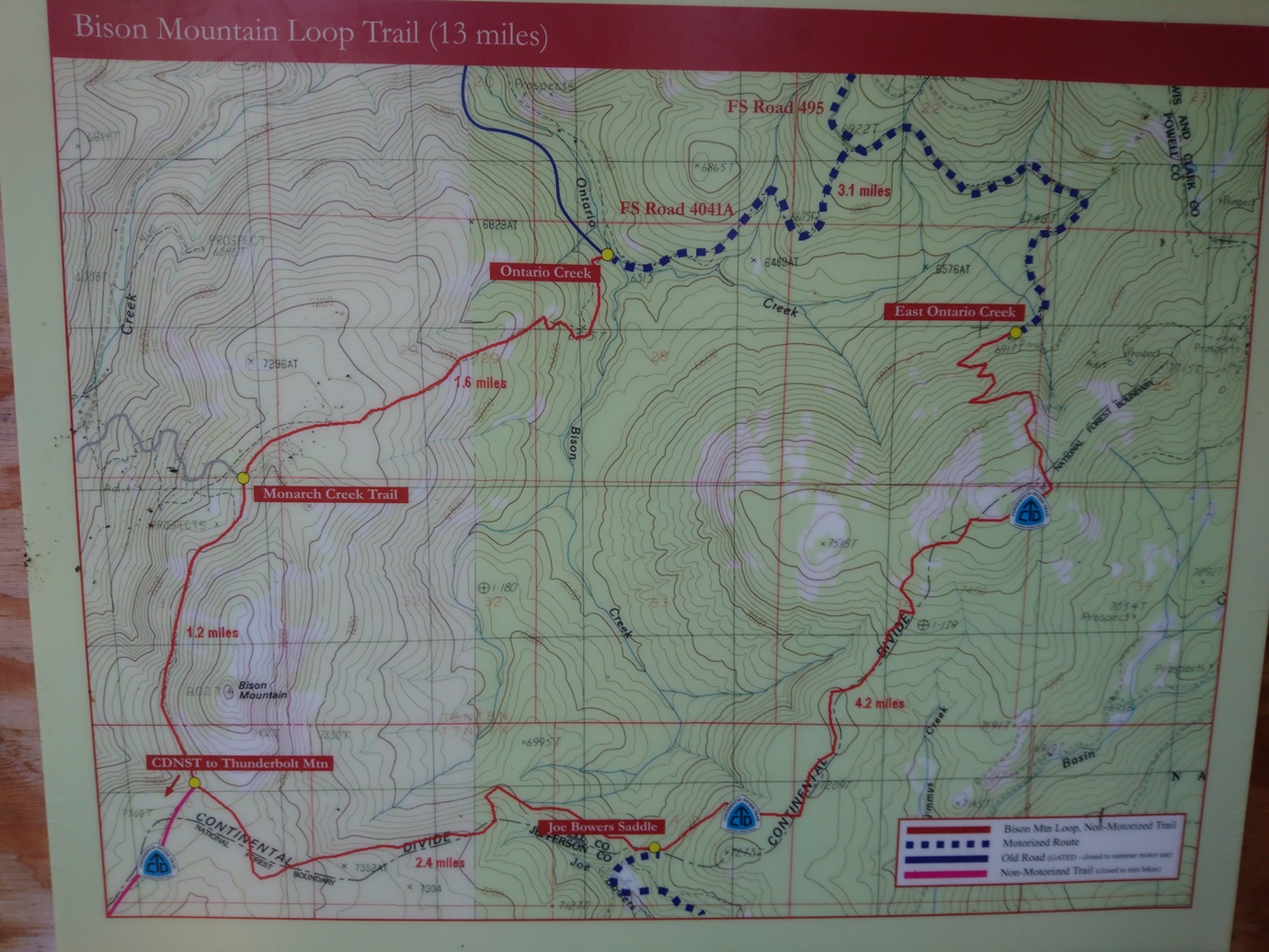
After a couple miles I reached an area called the Bison Mountain loop. In guthook, there’s a marker for trail junction here. Several people commented that the mileage listed in guthook is wrong in this area. Instead of being something like 3.9 miles it was probably around 10. That means I’m now several miles behind schedule, since I hadn’t accounted for these additional miles when planning for this section.

Today was another mix of forested trail and dirt roads. Some occasional distant views but mostly just forest. I saw two hunters and a woman walking her dog today. The woman asked if I was going to McDonald pass this evening, I said yes, approximately. She then offered to let me stay at her place, as she had hosted several CDT hikers in the past as well. I politely declined and stated my intentions were to stay on trail and try to cover miles. As much as I would love to, I know that I will just end up staying up late and or getting to the trailhead late tomorrow, and that’s not going to help my cause of getting to Lincoln any faster.

Filtered water from a small stream before heading back up to the divide where it looks dry. I was hoping to get to McDonald pass but I end up stopping a mile before the highway. Otherwise, I had a mile road walk along the highway and then probably at least a mile to get away from the highway before I could find camp on the other side. It was already 8pm and pretty much dark, not to mention I had a decent place to Camp right here.

Cowboy camped tonight under a pretty bright moon, a blinking red radio tower thing, and the sound of highway traffic.

Miles – 28
Total Miles – 2612
Rain – no
Sleep – backcountry, cowboy camp
Animals – none

Monday September 17th – CDT Day 150

Good night of sleep. The ball of my right foot hurt when I went to sleep last night, and still did this morning. Bummer. I took an ibuprofen, and I believe it’s the first one on trail (not counting ONE in town). Many hikers eat them like candy, referring to them as “Vitamin I”.


Walked the mile to McDonald pass and continued on the other side. Cell towers and such at the top of the hill on my first climb.

Walked a few miles until I reached a junction with a road. If I make a left here, I can follow the road and cut off a few miles from the official CDT route. It’s not like I’m missing anything. OK, sold!

Much of the road walk passes through private property, with permission to use the road only. Lots of cows everywhere. Filtered water from a stream that I later found out was filled with cow shit all the way to its source, which I walked to eventually. But I’ve filtered from similar in New Mexico and was fine, so I wasn’t too worried.

The road eventually led up to Meyers hill where I rejoined the CDT again. The ley alternate I was hiking was 8 miles, a savings of 6 from the 14 miles of official trail.

I took a break near Dana spring which was dry. Fortunately I had 2.5L still.

After my break, I started the climb up black mountain. I was walking with my head down when I heard a voice… “hey! hey!!” The, coming out of the trees was Hopeful! This was such a pleasant surprise as we could both use the company. We sat down and caught up on things for about 15 minutes before hitting the trail together.

The climb up black mountain seemed to go by much faster than it would have alone. Then another climb up to Nevada mountain. On the descent, we found camp just as it got dark.

It was great having someone to hike with again! Cowboy camping under the stars again tonight.

Miles – 29
Total Miles – 2641
Rain – no
Sleep – backcountry, cowboy camp
Animals – elk

Tuesday September 18th – CDT Day 151

It was another cold morning. Frost on everything including my sleeping bag.

This mornings hike was nice, with some distant views and ridge walking. There hasn’t been much of either lately.

We took a dirt road that skirts the mountainside below Granite Butte, saving a bunch of elevation gain. We did miss out on the view from the lookout tower, but this road was the way to the only water around for miles, so that made it an easy choice.

The road led us to Stemple pass. Here we dumped our trash in a trash can inside the outhouse and topped off water from a water cache.

Walked at a good pace the rest of the day. Covered 14 more miles and put us within 11 miles of Roger’s pass for tomorrow. However, the weather is calling for rain in the morning, so hopefully it holds off long enough to get packed up and moving. Or just doesn’t rain at all.

Miles – 26
Total Miles – 2641
Rain – no
Sleep – backcountry, tent
Animals – none

Wednesday September 19th – CDT Day 152

Woke up in a cloud this morning. Cold, misty, low visibility. Immediately climbed 600ft. Feet soaking wet. Stopping meant being cold, so we just kept moving.

There were a couple of climbs today, but none that were too big. However, there were no views of anything as the cloud cover remained pretty consistent with visibility of around 100′ or less.

After about 4 hours and 12 miles, we reached Roger’s pass. There was a tarp and a tent set up in the field just before hwy 200. I just walked right by and towards the road, ready to hitch. Hopeful was more observant, and noticed a whiteboard near a couple lawn chairs with both our names on it, literally. It was a trail angel named River Wulf, camped Under the tarp. He was hanging out here supporting CDT hikers… Whiskey, beer, solar charging etc. We chatted for a few minutes before heading up to the road to hitch.

Rogers Pass

Hitching sucked today. It was freezing cold and we were wet, shivering uncontrollably. The traffic was there but nobody would stop. I had my thumb out and one driver gave me a thumbs up. Very frustrating! Finally a guy named Tom picked us up on his way home from a traveling sales trip.

Ate lunch at Lambkins, then got a room at Three Bears Motel. A hot shower felt amazing! I was not fully warm until now.

In the hiker box at the motel, I snagged a sawyer filter for its gasket. This fixed my missing gasket issue on my filter. This was one of maybe two items where I pulled something useful out of a hiker box while on trail. It surprised me how many hikers relied on or used the hiker boxes extensively, as I thought most of the stuff in there was usually junk or food I didn’t want.

Ate dinner at The Wheel Inn, and had a couple beers. Long day!

Miles – 12
Total Miles – 2653
Rain – yes
Sleep – hotel
Animals – none

Thursday September 20th – CDT Day 153 (zero day)

Ate breakfast at Lambkins. Did chores all day… Ranger station, hardware store, atm, groceries, post office etc. Ate lunch at the Bootlegger Inn. Another great burger.

Met River Wulf for dinner at the Scapegoat Eatery. He was going to hitch back to the pass tonight but decided to stay in town. Only problem is, all his gear is back up at the pass. He was going to just sit under a tree at Hooper Park all night with all his layers on, and that sounded damn cold. I offered to let him stay with us at the motel, and just sleep on the ground. Obviously he accepted!

Related Images:

Darby to Anaconda – CDT Thru Hike 2018

Continental Divide Trail – Darby to Anaconda Hike Overview

darby to anaconda hike on the continental divide trail 2018

The first 30+ miles north of Chief Joseph Pass were pretty awful. Partially my fault due to a crazy thick bushwhack, but mostly due to never-ending forests of dead trees and burned trees while doing lots of elevation gain and no view of anything. Soon after, the Anaconda Pintler wilderness starts and offers some redeeming views, mostly in the northern section. Bear activity was high, with lots of fresh scat. Temperatures are getting noticeably cooler now and days are getting shorter. 

Monday September 10th – CDT Day 143

Slept in till about 8 this morning. Headed over to Park Place Cafe for breakfast, being the only place open. Another place that serves big portions. I could only eat half of a three stack pancake order!

Next I took care of my grocery shopping. The people’s market was amazing compared to Lima and Leadore, where I resupplied from gas stations. Then I worked on getting a list of items together for my dad to send me at East Glacier. This way, when I’m done with the hike I can pick up a box full of non-hiking items like blue jeans and a dedicated GPS unit to use in the rental car that I will use to drive back home in.

Back at Travellers Rest, I was packing up my stuff when Jim, Mary’s husband and the other owner of Travellers Rest, approached me and asked if I needed a ride back up to Chief Joseph pass. They were going to do a little biking up there in an hour or so. Perfect!

With an hour to kill, I headed up to the post office to send some things back home and send my bounce box ahead to Lincoln. I stopped in a fly shop along the way back and picked up a t-shirt for 8 bucks. Of course, right after I sent my bounce box back. Every time!

Trying out these new Salomon Odyssey Pro shoes

I reached Chief Joseph pass around 1pm. Today I’m trying out a pair of Salomon Odyssey Pro shoes. The Salomon rep I met in Yellowstone had sent these to me to test out. Initial impression are great, the shoe feels comfortable and has felt great walking around town. Let’s see how they hold up to the conditions a thru hiker faces on the CDT.

Not far from the pass, a ley alternate splits off from the official CDT. It looks like it cuts off a few miles, taking a nice flat dirt road instead of ups and downs through likely nondescript forest and ridges. Yeah, I’m into that.

I missed a few turns today and had to backtrack about 2 miles total. Guthook doesn’t show this alternate, but I have it loaded in Gaia on my phone. The free version of Gaia sucks though. Even when I’ve downloaded the detailed maps surrounding my track, they don’t show. Or the maps show up in patches. I was basically following a blue arrow on a grey screen.

When it was time to leave road for trail, ley suggests taking an old cross country ski trail. This might be OK in the winter, and for skiers, but it was soggy and overgrown here and now. Didn’t want to bushwhack uphill through this so I walked down to the next road leading uphill. Then I follow some old railroad grade.

The farther I walked along that railroad grade, the worse it became. Lots of deadfall. Like, no way to step around it because there was so much. Lots of small pine trees taking up the rest of the available ground space. This stopped me in my tracks.

I decided to bushwhack straight up hill towards a road on my map. Crawling over the piles of downed trees and wading through thick pines, I fought my way to the top. This was one of the nastiest bushwhacks I’ve done.

On the road now, I took a side trail leading up to the Divide. Here I reconnected with the CDT again. Shortly after I took a break for dinner.

Knocked out a few more miles after dinner in pursuit of Schultz saddle. I was disappointed to see a truck and camper here using the site. I put on by headlamp and got ready to do some night hiking. Luckily, I didn’t have to go far. Found a a small flat spot a few hundred yards away and cowboy camped here.

Miles – 19
Total Miles – 2449
Rain – no
Sleep – Backcountry, cowboy camp
Animals – none

Tuesday September 11th – CDT Day 144

Last night was cold. 25° when I woke up. Frost on my sleeping bag and clothes. I shivered throughout my morning routine and skipped breakfast in lieu of getting moving to get the blood pumping.

After an hour, I stopped in the first patch of sun I came across to eat breakfast. I could also remove layers now.

I gotta say, today was one of the more boring days I’ve done on the CDT. Every since I left chief Joseph pass, it’s just been downed trees and burn areas. Really bleak looking. This continued all day long. It also included many ups and downs. I did see about 5 elk in the forest this evening, but didn’t have a clear view.

It had gotten progressively cloudier throughout the day, and was now cold and windy as well. Tomorrow morning it might rain according to the last forecast I saw.

I made camp at a trail junction below pintler pass. I was surprised to see a tent and hammock set up here already. I chose a spot nearby but far enough away. I wonder if they’re CDT hikers?

Miles – 28
Total Miles – 2477
Rain – no
Sleep – Backcountry, tent
Animals – elk

Wednesday September 12th – CDT Day 145

I thought there was two people in the campsite next to me, but I think it was only one. I saw one person return by headlamp right before I jumped in bed last night, and heard one person leave this morning before I left my tent. I think it was a hunter.

Today is the day of climbing. Non-stop climbing, all day. If I were to hit my mileage goal, it would encompass at least 8500′ elevation gain. Not looking forward to today at all.

Right after leaving camp I climbed up pintler pass, and descended to Johnson Lake. This is where I would have liked to have made it to last night, ideally. This Lake marks the end of the southern Montana/Idaho map in my Guthook App, and the beginning of the northern Montana map, the final map.

After Johnson Lake the trail drops some more before going up another pass. Rainbow pass, Rainbow Lake. In this area, I crossed paths with 2 older guys out for a 30 mile hike. First actual hikers I’ve seen out here. A little further up, I stopped for a break.

The trail drops down another Valley to go around a steep Ridgeline and then heads uphill again. After cresting the pass, the trail swing by Warren lake. Nice mountain backdrop, it’s been a while since I’ve seen one like this.

I took another break below Warren Lake. I’ve been sweating going uphill, but going downhill or stopped I was freezing. Light snowflakes were falling, very light. As I descended downhill after the break, it turned into more of a rain than snow. It rained for about 2 hours and then within a matter of minutes, the Sun was out and the skies were completely blue.

Went over yet another pass, cutaway pass I believe. Then dropped down into Queener Basin and found camp around 7:30. I would have liked to have pressed on for another 30 or 45 minutes but there was another pass to climb and I didn’t feel like hiking in the dark. My shoes are wet and it’s going to be a cold night. Plus, I needed water which was next to camp. However, only 24 miles on the day. This was one of my lowest full days of hiking in a very long time.

It felt so good to get in my sleeping bag. I was really cold, especially my shriveled feet.

Miles – 24
Total Miles – 2501
Rain – yes, snowflakes
Sleep – Backcountry, tent
Animals – none

Thursday September 13th – CDT Day 146

Last night was cold but I stayed warm in my bag. There were a few sprinkles overnight but overall my tent was dry this morning. I threw on all of my available layers other than sleeping clothes to stay warm. My shoes were still soaked from yesterday, but that’s where having that second pair comes in handy!

As much as I’d planned for an early start this morning, I was just slow to get going into the cold and what I thought was going to be immediately rainy weather. I didn’t start hiking until around 8am.

No more than a quarter mile from Camp I encountered two fresh piles of bear scat. Definitely from this morning. Look like grizzly scat to me. Add that with the one last night, and Queener Basin is one place I’m glad I don’t have to spend another night.

As usual I had a hard time getting going with the climbing this morning. I’m just so burnt out with it. It wears me out and I dread any sign of uphill hiking these days. Just another sign I am so ready to be done with this thru hike. The last part is the hardest for sure.

I went over two passes this morning and both of them had the most beautiful scenery I’ve come across in the anaconda pintler wilderness. It’s a shame the trail spends so much time in the woods and forest and not up on the ridge lines. However, from what I can tell the beautiful part of this wilderness is not very widespread. Maybe a 15 mile segment of the about 100 miles from Chief Joseph pass to Anaconda.

On top of the second pass, the anaconda alternate route splits off from the CDT. The trail goes up hill a little bit, passes through goat flats, then skirts the mountainside over to another pass. From this pass the trail drops down to storm Lake.

On my way down to Storm Lake I was looking at my guthook map. It had the trail dropping down around the lake and then going way back up this Valley. I was looking at Bushwhacking across the valley to cut off a mile or two around the lake when I noticed a trail leading downhill from the lake. This trail became a road and goes all the way to highway 1, where I need to go anyway. This would save me a couple of miles total, and several miles of Trail walking. The new route would put me on a road the whole way into Anaconda, and so I can cover miles easier and faster. Realistically, it was going to be quite a push to get into town tonight anyway since I was looking at around 34 miles. So at least this gives me a shot, and a shot by dark no less.

About a mile before reaching Highway 1, it started raining. There was nowhere to take cover and if there was, it was private property. It rained for at least an hour. After the rain let up, I came across a campground. I headed over to the outhouse, as these usually have a little covered area outside for shelter. This one was no different, so I stopped here for a lunch break.

The rain had cleared by the time I was done eating lunch. The road walk went through some pretty country for being a highway. Started getting warm and I shed off all my layers. Of course after doing so, storms started building again. Super dark and nasty looking clouds behind me, with some crazy wind gusts. But I got lucky and this one passed to the side of the highway.

My Salomon Odyssey Pro shoes were starting to bother the calluses on the outside of my heels, so I switched back to my Cascadia 13s. It felt much better but the damage was already done. Nothing too crazy I can’t deal with, but if I had waited till I got into anaconda things would have been much worse.

I got into anaconda a little after 7. I stopped at the Dairy Queen but they were closed. Bummer! From here I called tradewinds motel to reserve a room and then headed out to find dinner. I stopped at a place called wings and things and got some great Wings. Not many places do a dry rub and I liked this one.

It was almost 9 by the time I got to my motel. I started charging things, washing socks underwear and shirt in the sink and then took a nice hot shower. Time for bed, and this was a very comfy bed!

Miles – 31
Total Miles – 2532
Rain – yes
Sleep – hotel
Animals – deer

Related Images:

×